Indus River
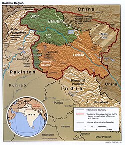
[8] The 3,180 km (1,980 mi)[5] river rises in mountain springs northeast of Mount Kailash in the Western Tibet region of China, flows northwest through the disputed region of Kashmir,[a][2] bends sharply to the left after the Nanga Parbat massif, and flows south-by-southwest through Pakistan, before emptying into the Arabian Sea near the port city of Karachi.
[12] These two Eurasian rivers, whose courses were continually diverted by the rising Himalayas, define the western and eastern limits, respectively, of the mountain range.
During the 2nd millennium BC, the Punjab region was mentioned in the Rigveda hymns as Sapta Sindhu and in the Avesta religious texts as Hapta Həndu (both terms meaning "seven rivers").
[9][17] The Indus River provides key water resources for Pakistan's economy – especially the breadbasket of Punjab province, which accounts for most of the nation's agricultural production, and Sindh.
[19] An extended figure of circa 3,600 km (2,200 mi) was announced by a Chinese research group in 2011, based on a comprehensive remeasurement from satellite imagery, and a ground expedition to identify an alternative source point, but detailed analysis has not yet been published.
The flow of the river is also determined by the seasons – it diminishes greatly in the winter while flooding its banks in the monsoon months from July to September.
There is also evidence of a steady shift in the course of the river since prehistoric times – it deviated westwards from flowing into the Rann of Kutch and adjoining Banni grasslands after the 1816 earthquake.
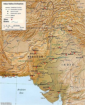
[25] The major cities of the Indus Valley Civilisation, such as Harappa and Mohenjo-daro, date back to around 3300 BC, and represent some of the largest human habitations of the ancient world.
The Indus Valley Civilisation extended from across northeast Afghanistan to Pakistan and northwest India,[26] with an upward reach from east of the Jhelum River to Ropar on the upper Sutlej.
In ancient times, "India" initially referred to those regions immediately along the east bank of the Indus, where are Punjab and Sindh now but by 300 BC, Greek writers including Herodotus and Megasthenes were applying the term to the entire subcontinent that extends much farther eastward.
[30][31] The lower basin of the Indus forms a natural boundary between the Iranian Plateau and the Indian subcontinent; this region embraces all or parts of the Pakistani provinces Balochistan, Khyber Pakhtunkhwa, Punjab and Sindh and the countries Afghanistan and India.
Still, after his Macedonians conquered the west bank—joining it to the Hellenic world, they elected to retreat along the southern course of the river, ending Alexander's Asian campaign.
Analysis of sediments from the Arabian Sea has demonstrated that before five million years ago the Indus was not connected to these Punjab rivers which instead flowed east into the Ganga and were captured after that time.
[33] Earlier work showed that sand and silt from western Tibet was reaching the Arabian Sea by 45 million years ago, implying the existence of an ancient Indus River by that time.
In the Nanga Parbat region, the massive amounts of erosion due to the Indus river following the capture and rerouting through that area are thought to bring middle and lower crustal rocks to the surface.
Extensive deforestation and human interference in the ecology of the Shivalik Hills has led to a marked deterioration in vegetation and growing conditions.
[41] In the uppermost, highest part of the Indus River basin there are relatively few genera and species: Diptychus, Ptychobarbus, Schizopyge, Schizopygopsis and Schizothorax snowtrout, Triplophysa loaches, and the catfish Glyptosternon reticulatum.
[40] In some upland lakes and tributaries of the Punjab region snow trout and mahseer are still common, but once the Indus basin reaches its lower plain the former group is absent and the latter are rare.
The Indus is the most important supplier of water resources to the Punjab and Sindh plains – it forms the backbone of agriculture and food production in Pakistan.
The extensive linking of tributaries with the Indus has helped spread water resources to the valley of Peshawar, in the Khyber Pakhtunkhwa.
The extensive irrigation and dam projects provide the basis for Pakistan's large production of crops such as cotton, sugarcane and wheat.
[48] Originally, the delta used to receive almost all of the water from the Indus River, which has an annual flow of approximately 180 billion cubic metres (240×10^9 cu yd), and is accompanied by 400 million tonnes (390×10^6 long tons) of silt.
[citation needed] As a result, the 2010 Pakistan floods were considered "good news" for the ecosystem and population of the river delta as they brought much-needed fresh water.
[54][55] Vegetation and wildlife of the Indus delta are threatened by the reduced inflow of fresh water, along with extensive deforestation, industrial pollution and global warming.
Qin Dahe, the former head of the China Meteorological Administration, said the recent fast pace of melting and warmer temperatures will be good for agriculture and tourism in the short term, but issued a strong warning: Temperatures are rising four times faster than elsewhere in China, and the Tibetan glaciers are retreating at a higher speed than in any other part of the world...
[58]"There is insufficient data to say what will happen to the Indus," says David Grey, the World Bank's senior water advisor in South Asia.
U.S. diplomat Richard Holbrooke said, shortly before he died in 2010, that he believed that falling water levels in the Indus River "could very well precipitate World War III.
[67] In early August, the heaviest flooding moved southward along the Indus River from severely affected northern regions toward western Punjab, where at least 1,400,000 acres (570,000 ha) of cropland was destroyed, and the southern province of Sindh.
[72] Sindh is a fertile region and often called the "breadbasket" of the country; the damage and toll of the floods on the local agrarian economy was said to be extensive.
[77] In response to the levees construction, the river has been aggrading rapidly over the last 20 years leading to breaches upstream of barrages and inundation of large areas.