Interface area
They have been defined as "the intersection of segregated and polarised working class residential zones, in areas with a strong link between territory and ethno-political identity".
[10] Trouble in the area has been a regular feature with petrol bombs thrown in 2000 and 2001 after local UDA Brigadier Jimbo Simpson claimed that republican housing was starting to encroach into Tiger's Bay.
[12] Further north another major flashpoint exists between the republican Ardoyne area and the loyalist Glenbryn estate, with this clash reaching its apex in the above mentioned Holy Cross dispute of 2001 and 2002.
During the summer of 1996 the Ulster Volunteer Force in Torrens had been preparing to attack Ardoyne after local disturbances, although they were talked out of it by Progressive Unionist Party politician Billy Hutchinson.
The Parades Commission has determined that marches be prevented from crossing Ormeau Bridge in recent years, and tensions have since reduced.
Reports of rioting between the two communities go back to at least the 19th century and in the post-war years violence between the young people from both sides was common on the many streets that linked the two areas.
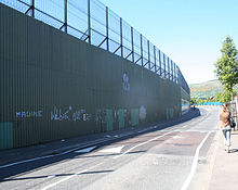
[20] Following the outbreak of the Troubles and a huge upturn in violence in these areas most of the direct points of access were sealed by peace lines, generating pockets of urban voids marked by dereliction and abandonment.
[24] The interface between the loyalist Corcrain Road and republican Obins Drive has been a regular scene of violence in the County Armagh town.
After Operation Motorman and the end of Free Derry, sectarian violence became worse and the peace lines grew rapidly in the Protestant Fountain area bordering the Catholic Bishop Street.