Interstate 215 (California)
While I-215 connects the city centers of both Riverside and San Bernardino, its parent I-15 runs to the west through Corona and Ontario.
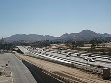
It then runs north through Menifee and northwest through Perris, passing March Air Reserve Base before joining State Route 60 (SR 60) in Riverside, near the Moreno Valley city limits.
From just north of downtown Perris to eastern Riverside near the Central Avenue interchange, the tracks of Metrolink's 91/Perris Valley Line run along the freeway.
This route offers a slight distance advantage as an alternative to I-15's alignment about 10 miles (16 km) to the west of (and roughly parallel to) I-215.
However, the traffic and time "advantage" on I-215 is limited by three factors: the segment between the I-15/I-215 "Devore junction" and north of SR 210 in San Bernardino only has two lanes in each direction (while I-15 has four), its co-designation with SR 60 and routing through Riverside requires motorists in both directions to "change freeways" to remain on I-215, and that most of I-215 has a 65 mph (105 km/h) speed limit (except for a short segment in northern San Bernardino north of Palm Avenue, which has a 70 mph (110 km/h) speed limit).
[7] Unofficially, I-215 is known as the Armed Forces Freeway between I-15 and SR 60, given its proximity to the March Air Reserve Base.
Two railroad crossings had also intersected the I-215 expressway at SR 74 and south of Cactus Avenue at then–March Air Force Base.
Motorists traveling east–west on SR 60 must begin counting exits at a new number, in the reverse order, during the I-215 overlap.
[14] Long-range plans include adding a carpool lane in each direction on a 10.75-mile (17.30 km) section of I-215 between Nuevo Road in Perris and SR 60 near Moreno Valley.