Interstate 69 in Michigan
The freeway continues to Port Huron before terminating in the middle of the twin-span Blue Water Bridge while running concurrently with I-94 at the border.
The freeway was not included on the original Interstate Highway System planning maps in the mid-1950s, but it was added in 1958 along a shorter route.
US 27 previously ran concurrently with I-69 from the Indiana–Michigan state line north to the Lansing area, but this designation was removed in 2002.
The entirety of I-69 is listed on the National Highway System,[4] which is a network of roadways important to the country's economy, defense, and mobility.
I-69 curves around the east side of Coldwater, connecting to the city's business loop on the south of town.
Immediately east of downtown, the freeway intersects the northern end of the business loop at an interchange that also features US 12 (Chicago Road).
Farther north, the freeway turns to the northwest, crosses into Calhoun County and then over the St. Joseph River.
[7][8] In southern Eaton County, the freeway parallels the Battle Creek River north of the junction with M-78.
On the south side of Charlotte, I-69 turns northward, traversing an area to the east of downtown and crossing the former routing of US 27, which is now part of the business loop for the city.
Farther north, the freeway has a junction with M-50, a bridge over the Battle Creek River, and an interchange with the northern end of the business loop next to Fitch H. Beach Airport.
The freeway enters Clinton County, and just north of a crossing of the Grand River, I-69 turns eastward to separate from I-96.
The freeway continues parallel to the Looking Glass River through suburban areas north of Capital Region International Airport.
Continuing eastward, I-69 parallels Miller Road to the north as far as the city of Swartz Creek; east of town, the two roadways cross.
The freeway intersects Bristol Road near the Bishop International Airport and then crosses I-75/US 23 southwest of downtown Flint.
I-69, the railroad and the Swartz Creek all parallel into downtown Flint where the freeway intersects I-475 and M-54 (Dort Highway) before exiting the east side of the city.
On the east side of the community, the freeway turns back to the southeast as it enters the western edge of the Port Huron suburbs.
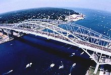
Past the interchange, the freeway crosses through the toll and customs plazas for the twin-span Blue Water Bridge.
The I-69 designation officially ends at the international boundary in the middle of the St. Clair River where it connects with Highway 402.
[25] The first span of the Blue Water Bridge opened between Port Huron and Point Edward, Ontario, in 1938.
[30] Around the same time, a section of M-146 near Port Huron was converted into an approach freeway for the Blue Water Bridge.
[34] Also in 1961, the MSHD had proposed that the section of US 27 south of Lansing be built as an electronic highway under a bid through General Motors;[35] the testing for such a roadway was ultimately done at Ohio State University instead.
[57][58] On September 4 of that year, I-69's designation was officially extended by Congress to end at I-475 on the east side of Flint;[49] this extension, and all subsequent ones, was of non-chargeable mileage, or segments not financed through the Interstate Highway fund.
[61] The remaining segment of freeway connecting Lapeer with Wadhams opened in 1984 as I-69 and several additional changes were made to the highway system at the same time.
The former route of M-21 in Port Huron became BL I-69, and the remainder of that highway was turned back to local control.
[52] The I-69 Recreational Heritage Route (now a Pure Michigan Byway) was created on October 8, 2004, to follow the freeway in Branch and Calhoun counties.
[80] The lane configuration changes have confused drivers in the area, especially those with outdated GPS devices,[81] a problem first noted as the department was preparing to reopen the freeway in October 2012.
[82] As a result, MDOT installed updated signs complete with American and Canadian flags to help prevent drivers from heading to Canada by mistake.
These highways, each designated Business Loop I-69 (BL I-69), provide access from the main freeway through the downtown districts of adjacent cities.


Concrete Gravel Water-bound macadam


 US 27
US 27
 M-78
M-78

