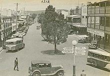
Inverell
Inverell is a large town in northern New South Wales, Australia, situated on the Macintyre River, close to the Queensland border.
[3] Around 1838, colonist Peter MacIntyre directed his employee, Alexander Campbell, to take up land in the area for his sheep and cattle.
[4][3] In the initial years, the local Aboriginal people resisted this occupation by spearing MacIntyre's shepherds and taking his livestock.
Wheat growers, Colin and Rosanna Ross established a store there in 1853,[7] and it was proposed that a town be surveyed.
Rich alluvial deposits in streams were worked initially by hand miners, but this ceased in the 1930s due to the economic effects of the Great Depression.
During the 1970s there were over 100 active mining operations in the New England region, however this number declined significantly in the 1980s due to weakening demand and exhaustion of the previously rich alluvial sources.
The Inverell district is in a fertile agricultural region which produces a wide range of crops, including wheat, barley, oats, sorghum, wine grapes and maize.
[24] Beginning in Grafton, passing through Glen Innes and finishing in Inverell, the Classic is a 230 km ride over the demanding Gibraltar Range.
Thunderbolts Way terminates at Copes Creek, 16 km south of the Gwydir Highway intersection at Inverell.
The local team are the Inverell RSM Hawks, who compete in the Group 19, playing out of Varley Oval.
The club has produced numerous National Rugby League players, including Owen Craigie and Phil and Chris Bailey.
Inverell, like most of the North West Slopes features a textbook subtropical climate with a marked summer peak in rainfall.
[34] Over the years, Inverell has had three weather stations run by government astronomers (prior to 1908) or the Bureau of Meteorology (after 1908), or both.