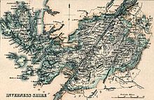
Inverness-shire
It is generally rural and sparsely populated, containing only three towns which held burgh status, being Inverness, Fort William and Kingussie.
The county is crossed by the Great Glen, which contains Loch Ness and separates the Grampian Mountains to the south-east from the Northwest Highlands.
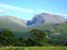
The county also includes Ben Nevis, the highest mountain in both Scotland and the United Kingdom.
The neighbouring counties prior to the 1975 reforms were (clockwise from north) Ross and Cromarty, Nairnshire, Moray, Banffshire, Aberdeenshire, Perthshire and Argyll.
[2] Around the same time, the Scottish crown was also trying to secure its control on Ross and Caithness (which then included Sutherland), the mainland provinces north of Moray.
The Scottish crown had claimed them since 1098, when Norwegian overlordship of that area had been ceded to Scotland but, like Moray, they had remained largely independent.
[5] That act was set aside for most purposes in 1509;[6] the northern areas eventually regained their independence from the sheriff of Inverness with the creation of the shires of Sutherland in 1633,[7] Caithness in 1641,[8] and Ross-shire in 1661.
In 1667 Commissioners of Supply were established for each shire, which would serve as the main administrative body for the area until the creation of county councils in 1890.
[15][16] Elected county councils were established in 1890 under the Local Government (Scotland) Act 1889, taking most of the functions of the commissioners (which were eventually abolished in 1930).
Notable changes included gaining the Small Isles of Canna, Muck and Rùm from Argyll.
Exceptionally, the parish of Croy and Dalcross was allowed to continue to straddle Inverness-shire and Nairnshire.
[28][29] The parts of Inverness-shire which went to the Highland Region were split between four lower-tier districts:[28][30] Prior to 1975, each county had appointed a lord-lieutenant.
(Scotland) Act 1994 saw the regions and districts created in 1975 abolished and replaced with single-tier council areas.
[30] The west coast of Inverness-shire was traditionally referred to as the Rough Bounds due to its remoteness and inaccessibility.
The larger inland lochs are:[a] Inverness-shire contains numerous small islands off its west coast which form part of the Inner Hebrides.
To the west, across the Little Minch, most of the Outer Hebrides fall within the county, with the notable exception of Lewis which is in Ross-shire.
[38] Much further west, 230 miles from the Outer Hebrides, lies the extremely remote, uninhabitable island of Rockall, which is subject to a territorial dispute with Ireland.
[40] The blazon read: The galley represents Clan Chattan, who aligned themselves under the banner of Somerled, Lord of the Isles.
As their areas have been largely unchanged since the 19th century this allows for comparison of population figures over an extended period.
[43] Many changes have taken place since the Reformation period: The Highland Main Line connects Inverness by rail to Perth to the south, Kyle of Lochalsh to the west, and Thurso/Wick to the north.
Various bus companies serve the larger towns of the county, such as Stagecoach Group and Scottish Citylink.
The region, until 1996, and the unitary Highland council area, 1996 to present, have been covered by three constituencies since then but there were changes to boundaries and names in 1997 and 2005.