Iredell County, North Carolina
[4][5][6][7] Iredell County is included in the Charlotte-Concord-Gastonia, NC-SC Metropolitan Statistical Area, as defined by the Office of Management and Budget, with data from the U.S. Census Bureau.
[8] Prior to colonization, three Siouan-speaking tribes associated with a culture group called the Eastern Siouans probably inhabited the area that is now Iredell County.
Broken into several smaller tribes, they were the Catawba, the Waccamaw Siouan, the Cheraw, the Winyah, the Wateree and the Sugaree.
The following list shows significant events and firsts in the history of the area that is now called Iredell County, North Carolina.
Although the "Brushies", as they are often called locally, are not high in the normal sense, they do rise prominently above the surrounding countryside.
The remainder of Iredell County consists of gently rolling countryside occasionally broken by low hills and small river valleys.
[45] The Iredell County Commissioners (2016–present) are James Mallory (chairman), Marvin Norman, Tommy Bowles, Jeff McNeely and Gene Houpe, all Republicans.
James Lee (Jim) Mixson III has served as Iredell County's Clerk of Superior Court since 2012.
Clerks of Superior Court in North Carolina also serve as Probate Judges in addition to their administrative duties.
Before 1952, however, Iredell was part of the Democratic "Solid South" and voted for no Republican presidential candidate after Reconstruction except Herbert Hoover in 1928.
In 1964, the year that national civil rights legislation was passed, it was one of 13 North Carolina counties to vote for Barry Goldwater.
In the past 17 elections, the only Democrat to carry Iredell County was Jimmy Carter in 1976, who was a native son of Georgia and the South.
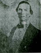
[52] One of the most famous prisoners held by Sheriff William Franklin Wasson in the Iredell County jail was Tom Dula, who was hung on May 1, 1868, in Statesville.
Although northern Iredell County has retained much of its rural character, the southern half of the county is experiencing rapid suburbanization and population growth, largely due to the immense popularity of the Lake Norman area for residents of nearby Charlotte, North Carolina's largest city.
[68][17] The following townships were created in 1868:[10][11] In the 1700s and 1800s, before there were many towns in what became Iredell County, property was identified by stream, rivers, or adjacent landowners.