Saba (island)
in the CaribbeanSaba (/ˈseɪbə/ ⓘ SAY-bə,[6] Dutch: [ˈsaːbaː] ⓘ)[7] is a Caribbean island and the smallest special municipality (officially "public body") of the Netherlands.
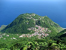
[8][9] It consists largely of the dormant volcano[10] Mount Scenery, which at 870 metres (2,854.3 ft) is the highest point of the entire Kingdom of the Netherlands.
On the basis of the navigational skills required, South America seems to have offered the most favourable conditions for reaching Lesser Antillean islands such as Saba.
During this time the inhabitants of Saba were full horticulturalists living from the cultivation of root crops and the exploitation of the marine environment.
They produced pottery vessels, made tools and sculptured objects from stone, shell, animal, bone, and coral.
[15] In 1664, refusing to swear allegiance to the English crown, these original Dutch settlers were evicted to St. Maarten by Jamaican governors pirates Edward, Thomas, and Henry Morgan.
Saba lace, a Spanish form of needlework introduced by a nun from Venezuela, became an important product made by the island's women.
[24][15] In 1943, Joseph "Lambee" Hassell, a self-taught engineer, designed the road on Saba, which was built by hand by island residents.
Saba is a small island at 13 square kilometres (5.0 sq mi) in size and roughly circular in shape.
The terrain is generally mountainous, and the centre of the island is dominated by its volcanic peak, Mount Scenery, which stands 870.4 m (2,856 ft) above sea level.
[36][37] Between 1995 and 1997, an increase in local seismic activity was associated with a 7–12 °C (45–54 °F) rise in the temperature of the hot springs on the island's northwest and southeast coasts.
[45] Formerly owned by the Sulphur Mining Company, the park was established in January 1998 and the property was officially turned over to the Saba Conservation Foundation in 1999.
The coastline of Saba is mostly rubble and rocky cliffs that are 100 metres (330 ft) or taller with mostly cobble and boulder permanent beaches.
[10] The steep terrain and sheer bluffs dropping almost straight down to the ocean's edge prevents the formation of mangrove swamps or much vegetation.
[44] Saba's coastline also includes the Flat Point Tide Pools, which were created by a large lava flow thousands of years ago.
[39] Saba's shoreline is home to the Caribbean's largest breeding colony of Red-billed tropicbird (Phaethon aethereus).
[38] About 4.3 kilometres (2.7 mi) southwest of the island is the northeastern edge of the Saba Bank, the largest submarine atoll in the Atlantic Ocean[51] with an especially rich biodiversity.
The population is also partly descended from the Irish who were exiled from that country after the accession of King Charles I of England, Scotland and Ireland in 1625.
Charles exiled these Irish to the Caribbean in an effort to quell a rebellion after he had forcibly procured their lands for his Scottish noble supporters.
[75] The first contact with Christians on the island occurred with the visit of Christopher Columbus in 1493, but this did not mean the immediate arrival of the Catholic Church.
[79] Missionary activity, the arrival of immigrants from other parts of the Netherlands and other territories in the Caribbean and Europe made the Catholic Church the most popular denomination in the present day, as it represents nearly half of the population.
Its construction was masterminded by Josephus Lambert Hassell who, contrary to the opinion of Dutch and Swiss engineers, believed that a road could be built.
Only trained pilots flying small STOL airliners, such as the Twin Otter and the Britten-Norman Islander, may land there, as well as helicopters.
[99] Like many Caribbean islands, Saba is dependent on fossil fuels imports, which leaves it vulnerable to global oil price fluctuations that directly affect the cost of electricity.
[102][103][104] According to a report by the Low Emission Development Strategies Global Partnership (LEDS GP), the Government of Saba made the decision to transform the island to 100% sustainable energy to eventually eliminate dependence on fossil fuel-generated electricity.
Rent is unaffordable for many local residents on the island, pressures include the high cost of utilities and groceries, as well as limited housing.
There is also a "public-private partnership between the [Dutch] public entity and the United States-based corporation Gezondheid Farms" to increase access to hydroponically-grown local produce.
Saba's Carnival takes place the last week in July and includes parades, steel bands, competitions, and food.
The Bottom holds host to a concert at the sports field where local and other Caribbean artists come to perform.
A wahoo fishing tournament is also held during Saba Day and attracts boats from neighboring islands such as St. Maarten, St. Eustatius, and St. Barths.