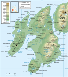
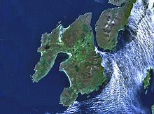
Islay
The later medieval period marked a "cultural high point" with the transfer of the Hebrides to the Kingdom of Scotland and the emergence of the Clan Donald Lordship of the Isles, originally centred at Finlaggan.
[38][42] In comparatively recent times the island was ice-covered during the Pleistocene glaciations save for Beinn Tart a' Mhill on the Rinns, which was a nunatak on the edge of the ice sheet.
[62] The ruins of a broch at Dùn Bhoraraic south east of Ballygrant and the remains of numerous Atlantic roundhouses indicate the influences of northern Scotland, where these forms of building originate.
[29][63] By the sixth century AD Islay, along with much of the nearby mainland and adjacent islands, lay within the Gaelic kingdom of Dál Riata with strong links to Ireland.
The widely accepted opinion is that Dál Riata was established by Gaelic migrants from Ulster, displacing a native Brythonic culture (such as the Picts), but some scholars claim that the Gaels in this part of Scotland were indigenous to the area.
[65] Dál Riata was divided into a small number of regions, each controlled by a particular kin group; according to the Senchus fer n-Alban ("The History of the Men of Scotland"), it was the Cenél nÓengusa for Islay and Jura.
[69] Gaelic continued to exist as a spoken language in the southern Hebrides throughout the Norse period, but the place name evidence suggests it had a lowly status, possibly indicating an enslaved population.
The Chronicles of Mann call Godred the son of Harald the Black of Ysland, (his place or origin variously interpreted as Islay, Ireland or Iceland) and state he "so tamed the Scots that no one who built a ship or boat dared use more than three iron bolts".
[68] Following Godred's death, the local population resisted Norway's choice of replacement, causing Magnus, the Norwegian king, to launch a military campaign to assert his authority.
In 1266, his more peaceable successor ceded his nominal authority over Suðreyjar to the Scottish king (Alexander III) by the Treaty of Perth, in return for a very large sum of money.
Successive chiefs of Clan Donald were proclaimed Lord of the Isles there, upon an ancient seven-foot-square coronation stone bearing footprint impressions in which the new ruler stood barefoot and was anointed by the Bishop of Argyll and seven priests.
[93] In 1462, the last and most ambitious of the Lords, John MacDonald II, struck an alliance with Edward IV of England under terms of the Treaty of Ardtornish-Westminster with the goal of conquering Scotland.
A charter was soon sent from the Scottish King confirming this state of affairs; it declares that Skye and the Outer Hebrides are to be considered independent from the rest of the former Lordship, leaving only Islay and Jura remaining in the comital unit.
A Covenanter army under Sir David Leslie arrived on Islay in 1647, and besieged the royalist garrison at Dunnyvaig, laying waste to the island.
[107] At the beginning of the 18th century much of the population of Argyll was to be found dispersed in small clachans of farming families[108] and only two villages of any size, Killarow near Bridgend and Lagavulin, existed on Islay at the time.
[115] Initially, a sense of optimism in the fishing and cattle trades prevailed and the population expanded, partly as a result of the 18th-century kelp boom and the introduction of the potato as a staple.
Islay remained with the Campbells of Shawfield until 1853 when it was sold to James Morrison of Berkshire, ancestor of the third Baron Margadale, who still owns a substantial portion of the island.
[119] The SS Tuscania, a converted British liner carrying American Doughboys to France, was torpedoed by SM UB-77 on 5 February with the loss of over 160 lives and now lies in deep water 6.4 km (4 mi) west of the Mull of Oa.
[142] In general, the whiskies from this island are known for "pungent peaty, smoky and oily flavours, with just a hint of salty sea air and seaweed" because of the use of peat and the maritime climate, according to one report.
[153][154] The location of Islay, exposed to the full force of the North Atlantic, has led to it being the site of a pioneering, and Scotland's first, wave power station near Portnahaven.
[159] Kintyre Express will begin operating passenger only services between Port Ellen and Ballycastle in Northern Ireland from Fridays to Mondays through June, July and August.
[165] In the early 21st century a campus of Sabhal Mòr Ostaig was set up on Islay, Ionad Chaluim Chille Ìle, which teaches Gaelic language, culture and heritage.
[167][168] A 16 miles (26 km) submarine telegraph cable was laid in July 1871 between Ardenistle near Port Ellen on Islay and Kintyre using the SS Robert Lowe.
[177] The other distilleries followed suit fairly shortly after this, but except for a few people who could afford to install generating plant themselves, electricity was not provided generally for domestic consumption until after the Second World War.
In 1937 it was reported in the Oban Times and Argyllshire Advertiser of 22 May 1937 that on Coronation Day in Bowmore through the ingenuity of Mr Allan Cameron, chemist, part of the village was floodlit for two nights by electricity from his private plant.
This showed that the generating plant at RAF Bowmore would prove suitable for temporary use in providing supplies in the early stages of a distribution scheme for the island.
[185] It sits within a group of lexical isoglosses (i.e. words distinctive to a certain area) with strong similarities to the southern Scottish Gaelic and Ulster Irish dialects.
[197] The diocese fell within the jurisdiction of the Archdiocese of Nidaros and there were four principal churches on Islay in the Norwegian prestegjeld model: Kilnaughton, Kildalton, Kilarrow and Kilmany.
[203] In 1967–68, folk-rock songwriter and singer Donovan included "Isle of Islay" in his album, A Gift from a Flower to a Garden, a song praising the pastoral beauties of the island.
[210] Resident birds include red-billed chough, hen harrier, golden eagle, peregrine falcon, barn owl, raven, oystercatcher and guillemot.