Lismore, Scotland
Lismore (Scottish Gaelic: Lios Mòr, pronounced [ʎis̪ ˈmoːɾ] possibly meaning "great enclosure" or "garden") is an island of around 2,351 hectares (9.1 square miles) in the Inner Hebrides of Scotland.
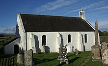
This fertile, low-lying island was once a major centre of Celtic Christianity, with a 6th-century monastery associated with Saint Moluag, and later became the seat of the medieval Bishop of Argyll.
The limestone country rock is intruded by a handful of NE-SW aligned lamprophyre dykes of Silurian to early Devonian age associated with the Strontian Granite Complex and by large numbers of NW-SE aligned dykes of dolerite and basalt of Palaeogene age along with a rather fewer number assigned to the ‘Loch Scridain Suite.
Quaternary deposits include glacial till and peat alongside some small patches of alluvium (clay, silt, sand and gravel) which occupy lower ground.
[14][15][16] The island of Lismore lies in Loch Linnhe, north east of Mull, in the Argyll and Bute council area.
[6][17][18] The area of the island is 2,351 hectares (9.1 square miles)[3] and the highest elevation is Barr Mòr in the south above Kilcheran, which reaches only 127 metres (417 feet).
Although Barr Mòr is only of modest height, from there "the skyscape is vast and made so not by its emptiness, but by the throng of high and pointed hills lifting out of the glittering seas and islands.
[28] The whole island of Bernera is also an SSSI, its limestone maritime cliffs being a key feature along with the presence of the nationally scarce rock whitebeam.
[4] Lismore Lighthouse, built by Robert Stevenson, lies on the small island of Eilean Musdile to the south west, with Lady's Rock a kilometre further away in the same direction.
The nearest official Met Office weather station for which online records are available is Dunstaffnage on the mainland north of Oban.
[32] Tirefour Castle is an Iron Age broch of an uncertain date that is a prominent landmark on Lismore's east coast.
The Iona Chronicle records the death of Mo-Luóc (also known as Moluag), who was probably abbot of the Lismore monastery in 594, and of his successors Neman in 613 and Eochaid in 637.
[35] Lismore probably maintained its status as the principal religious house of the Cenél Loairn during the remainder of the 7th century[36] and the deaths of abbots Iarnlaigh c. 700, Colmán in 704 and Crónán ua Eoain in 718 are recorded in the Annals of Ulster.
[38] In that year, Edgar of Scotland signed a treaty with Magnus which settled much of the boundary between the Scots and Norwegian claims in these islands.
Edgar formally acknowledged the existing situation by giving up his claims to the Hebrides but there were a few exceptions including Luing and Lismore, which were retained by the Scots.
Before the late 12th century the Bishopric of Dunkeld included all of Argyll, but sometime between 1183 and 1193 they were separated, as apparently the then Bishop John Scotus was unable to speak Gaelic.
[43] In the event St Moluag's cathedral at Clachan maintained its position until 1507, when the diocese's centre was moved to Saddell in Kintyre.
[3] It was burned down during the Reformation[41] and only the choir survives in greatly altered form, the nave and western tower having been reduced to their foundations.
[4] In the 16th century Donald Monro provided a brief description of the island in Scots: Lismoir, ane iyle quher leid ure is, fornent Douard.
He stated that both were "good for corn and store" and had many "Elders and thorns" and that Eilean Droineach was the "habitation of Bishops and Nobles in auld times".
[54] The Plod nam Baran, which is adjacent to the site of Saint Moluag's church, may be the burial ground of its clan chiefs, or "barons".
[60] The remains of another two kilns can be seen at Kilcheran near Lismore Seminary, a Roman Catholic divinity school that was in operation from 1803 to 1828 at a time when the other inhabitants of the island were staunchly Presbyterian.
The harbour patrol craft Appletree was sunk in a collision with an RAF pinnace east of the Lismore light in October 1940 with, according to one report, the loss of two lives.
[71] The majority of the resident working population are engaged in farming or fishing,[17][72] and sheep raised on the island have a reputation for quality.
In 2023, the sole shop on the island, which is also the post office, was threatened with closure because the person running it had decided to return to school teaching.
When the piping ceased the dog emerged sightless and hairless but the piper was presumed to have drowned in one of the cave's impassable pools and was never seen again.
Realising that he was going to lose, Moluag cut off his finger and threw it ashore north of the broch of Tirefour, enabling him to claim victory.