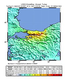
1999 İzmit earthquake
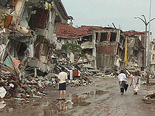
The earthquake lasted for 37 seconds, causing seismic damage, and is widely remembered as one of the deadliest natural disasters in modern Turkish history.
The fault eventually developed at the Marmara Sea around 200,000 years ago despite the shear-related movement in a rather broad zone which had already started in late Miocene.
Since the 17th century, it has shown cyclical behavior, with century-long large earthquake cycles beginning in the east and continuing westward.
This earthquake sequence began in 1939 and ruptured along a 1000-km part of the fault zone, with horizontal displacements of up to 7.5 m (25 ft).
The earthquake also caused serious damage in Istanbul, especially in the district of Avcılar which is located in the western part of the city, around 70 km (43 mi) away from the epicenter.
The maximum offset throughout the rupture was measured on the Sapanca–Akyazı segment where the surface break displaced a road and a tree line by 5.2 m (17 ft).
As a result, part of the town center slid under the water, including a hotel and several shops and restaurants.
Avcılar was built on relatively weak ground, mainly composed of poorly consolidated Cenozoic sedimentary rocks, which made the district vulnerable to earthquakes.
Government officials also faced backlash for not properly enforcing earthquake resistant building codes.
Along the northern coast of the gulf, in the basin between Hereke and Tüpraş Petroleum Refinery, the tsunami was recorded as a leading depression wave.
When the sea came back, it swept inland up to 35 m (115 ft), as shown by the mussels and dead fish left in the flooded areas.
[31] A Mw 5.2 aftershock occurred near İzmit on 31 August, causing one additional fatality and 166 injuries, with tremors being felt in Istanbul.
Within hours of the earthquake, the Greek Ministry of Foreign Affairs contacted their counterparts in Turkey, and the minister sent his personal envoys.
[41] Oil Spill Response Limited was activated by BP and deployed from the United Kingdom to the Tüpraş Refinery.
[43] US President Bill Clinton later visited Istanbul and İzmit to examine the level of destruction and meet with the survivors.
[44] There has been an increased seismic activity in the Eastern Sea of Marmara since 2002 and a quiescence of earthquakes on the Princes' Islands Segment of the North Anatolian Fault off the southern coast of Istanbul.
This suggests that the 150 km (93 mi) long submarine seismic gap below the Sea of Marmara could result in another large earthquake.
[45] Despite a long-term earthquake catalogue existing for the North Anatolian Fault Zone and for the Istanbul area in particular, the basic understanding of the seismicity there is still lacking.
This improved monitoring along the Princes' Islands segment, which is west of the İzmit 1999 rupture and southeast of Istanbul's city center.
It also limits the maximum size of future events along the whole Marmara seismic gap in case of cascade behavior.
The aseismic part of the Princes' Islands segment represents a likely high-slip area for a future large earthquake.
Fault characterization is likewise very relevant to determine the directivity of earthquake waves approaching Istanbul.
Modelling of potential impacts to Istanbul from different scenarios have shown to improve the estimation of hazards that the seismic gaps pose.
Improved and denser seismic monitoring is expected from on-going efforts to install an underground (borehole-based) seismograph network in the Sea of Marmara.
[45] Istanbul, being the most populated city in Turkey, lies right near the segments of the North Anatolian Fault Zone, making it at very high risk to an earthquake-related disaster which could cause thousands of casualties and severe damage.
With the help of organizations like the World Bank, hundreds of buildings have been retrofitted and reconstructed, and thousands of citizens have been trained in disaster preparedness.