Jamison Valley
The Jamison Valley forms part of the Coxs River canyon system in the Blue Mountains of New South Wales, Australia.
Later, as local towns were beginning to develop, the British naturalist Charles Darwin toured the area.
His route is now commemorated as Darwin's Walk, starting in Wilson Park, Wentworth Falls, and following Jamison Creek to the escarpment.
[3] Coal mining in the valley was started around 1872 by John Britty North, with large-scale infrastructure (Katoomba Scenic Railway) used to overcome the terrain.
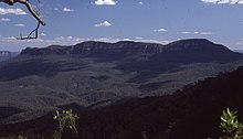
The Jamison Valley stretches north-south from just outside Katoomba to the Mount Solitary ridge; in this direction it is approximately 4 kilometres (2.5 mi) long.
From west to east, it stretches from Narrow Neck Plateau to Kings Tableland, making it approximately 10 kilometres (6.2 mi) wide.
It is joined to Narrow Neck Plateau by a low ridge which is also the site of the Ruined Castle, a rock formation that is popular with bushwalkers.
There is a 3 kilometres (1.9 mi) prohibited area around the river and lake to protect Sydney's water supply.
These service roads make it possible to do a trek taking in the whole valley, but it is necessary to get permission from Sydney Water to go through the prohibited area.