Jefferson Pier
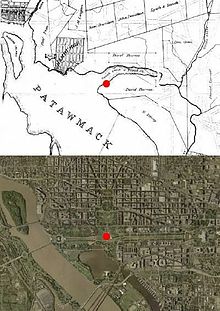
[5][6] According to a notation on Pierre (Peter) Charles L'Enfant's 1791 "Plan of the city intended for the permanent seat of the government of the United States ... " (see L'Enfant Plan), Andrew Ellicott measured a prime meridian (longitude 0°0') through the future site of the U.S.
[9] L'Enfant chose the west end of the "grand avenue" (at the triangle's southwest corner) to be the location of a future equestrian statue of George Washington for which the Continental Congress had voted in 1783.
In accordance with Jefferson's request, Isaac Briggs used a transit and equal altitude instrument[10] to survey a new meridian line extending south from the center of the President's House that intersected a line extending due west from the planned center of the Capitol building.
[11][12] On October 15, 1804, Nicholas King, Surveyor of the City of Washington, erected at the intersection "a small pier, covered by a flat free stone, on which the lines are drawn."
[2] The pier and stone were located at the point that L'Enfant's plan had identified as being the future site of George Washington's equestrian statue.
Due to errors either when the Jefferson Pier was initially surveyed or when it was replaced, its center is now 2.23 ft (0.680 m) south of the Capitol's centerline.
The developers of the Washington Monument originally wanted the memorial to be located at the site of the Jefferson Pier.
[15] Without recognizing the significance of the stone, the United States Army Corps of Engineers removed the original marker during 1872–1874 as part of a cleanup and grading of the grounds around the stump of the Washington Monument, which had not yet been finished.
As part of this project, the Corps of Engineers filled in gullies, planted trees and constructed ornamental ponds and a broad carriage road around the stump.
In 1920, Congress approved the placement of a new delineation stone on the Ellipse, the Zero Milestone, which is an itinerary marker from which official mileages from Washington would be determined.
[note 2] The new marker, a gift of the Lee Highway Association, was for some reason placed one foot west of the original meridian line extending north–south from the center of the White House.