Jeita Grotto
The Jeita Grotto (Arabic: مغارة جعيتا) is a system of two separate, but interconnected, karstic limestone caves spanning an overall length of nearly 9 kilometres (5.6 mi).
The caves are situated in the Nahr al-Kalb river valley within the locality of Jeita, 18 kilometres (11 mi) north of the Lebanese capital Beirut.
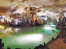
Though inhabited in prehistoric times, the lower cave was not rediscovered until 1836 by Reverend William Thomson; it can only be visited by boat since it channels an underground river that provides fresh drinking water to more than a million Lebanese.
[3] The Jeita cave is situated at the center of the western flanks of the Lebanon mountains, more specifically in the Nahr al-Kalb valley, its natural entrance is about 100 metres (330 ft) above sea level.
[2] The modern discovery of the underground river of Jeita in 1836 is credited to Reverend William Thomson (an American missionary) who ventured some 50 metres (160 ft) into the cave.
Reaching the underground river, he fired a shot from his gun and the resulting echoes convinced him that he had found a cavern of major importance.
About 200 metres (660 ft) further on, in the so-called "Pantheon", they wrote their names and details of the expedition on paper, sealed it in a bottle and placed it on top of a stalagmite.
[8] In 1962, the Spéléo Club contributed to a study of the upper galleries aiming to provide an access tunnel which was to be dug for touristic development purposes.
[11] In 1969, a concert with electronic music by the French composer Francois Bayle was held in the cave to celebrate the inauguration of the upper galleries.
[12][14] The caverns closed to the public due to the Lebanese civil war in 1978;[8] both tunnels leading to the lower and upper galleries were used to store munitions, and the outside buildings for military purposes.
Henri Fleisch noticed an Upper Paleolithic level with further finds including polished Neolithic pieces, primitive potsherds, burned bones, and end scrapers.
Evidence of later occupation included a Chalcolithic tripod pot found by Father Fleisch and a combed-ware sherd suggested to date to the Early Bronze Age levels at Byblos.
Flint tools found in the deposit were geometric in design and suggested to be a form of Natufian or later Mesolithic than discovered at Jeita II, from where it may have been displaced.
Forms of these flints included rectangles with straight or oblique truncation, borers of the "crochet" type, micro-burins, end scrapers, bladelet cores, two transverse arrowheads, crescents, and short triangles.
It once contained a large quantity of Paleolithic material which has been looted and was deemed unfit for excavation by Sami Karkaby, Director of the Caverns in 1965.
[19] The Jeita grotto is located within the Lower-Middle Jurassic strata of Keserouane which has a stratigraphic thickness of 1,000 metres (3,300 ft) and consists of dolomite and micritic limestone.
At the Nahr al-Kalb valley, the impervious Upper Jurassic volcanic rocks and Lower Cretaceous sand slant almost vertically forming a hydrogeological barrier and forcing the outlet of the Jeita underground river to the surface.
The upper cave contains a great concentration of a variety of crystallized formations such as stalactites, stalagmites, columns, mushrooms, ponds, curtains, and draperies.
MAPAS, the firm which runs the grotto, is an important employer and provides full-time jobs for around 115 local residents of Jeita (30% of which are female).
[29] Moreover, the Jeita cave emits a spring with a flow ranging from 1–2 m3/s,[31] providing fresh drinking water for one-and-a-half million inhabitants of the capital, Beirut.
[32] However, water pollution, due to domestic and agricultural runoff, remains a serious concern as recent analysis detected an increasing presence of coliform bacteria.
[citation needed] In December 2003, on behalf of the Beirut-based private company MAPAS, Jeita received a prestigious award from the fifth Tourism Summits in Chamonix, France.
Nahr al-Kalb is the name of the river that runs through the grottoes, while Jeita, meaning "roaring water" in Aramaic, is the town in which the cave's entrance is located.