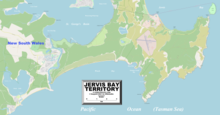
Jervis Bay Territory
The Yuin people have a continuing connection to the Jervis Bay area and in December 2016, applied for recognition of their native title.
[11][12] In August 1791, the British convict transport ship Atlantic of the Third Fleet entered the bay and Lieutenant Richard Bowen named it in honour of Admiral John Jervis.
[14] In 1915, jurisdiction over the Jervis Bay Territory was transferred from the state of New South Wales to the federal Commonwealth of Australia.
[9] The park itself encompasses approximately 90% of the territory of Jervis Bay and covers the overlap between Australia's northern and southern climatic zones.
Ancient sand dunes overlay the sedimentary bedrock formations formed from upheaval of the surrounding marine environment 280–225 million years ago.
The Wreck Bay Aboriginal Community Council owns approximately 68 km2 (26 sq mi), about 90% of the territory and exercises certain governance and representation functions for its community under the Aboriginal Land Grant (Jervis Bay Territory) Act 1986[20] The rest is managed by the Department of Infrastructure, Regional Development and Cities.
There are two villages in the Jervis Bay Territory: HMAS Creswell is the Royal Australian Navy College and associated naval facilities.
[citation needed] There are several private leasehold properties in the Jervis Bay Territory within but not part of Booderee National Park.
A group of buildings on the eastern foreshore of Sussex Inlet, known as the Christian's Minde Settlement, comprises of six separate parcels of land, four of which are leaseholds.
[23][24] Christian's Minde was promoted as the first guesthouse on the NSW south coast between Port Hacking and Twofold Bay when it was established in the 1890s.
Members of the extended family are buried in a cemetery, surrounded by dense bush, which is managed by the Wreck Bay Aboriginal Community Council.
Jervis Bay Territory is administered by the Commonwealth Department of Infrastructure, Transport, Regional Development, Communications and the Arts.