Kota Kinabalu
Kota Kinabalu (Malaysian: [ˈkota kinaˈbalu]; formerly known as Jesselton), colloquially referred to as KK, is the state capital of Sabah, Malaysia.
The Tunku Abdul Rahman National Park[6] lies to its west and Mount Kinabalu, which gave the city its name, is located to its east.
Development in the area was started soon after that; and the place was named "Api-api" before it was renamed after Sir Charles Jessel, the vice-chairman of BNBC, as "Jesselton".
[17] The Bajau locals purportedly used this name to refer to a village in the southern part of the city which was filled with coconut trees.
The site was chosen due to its proximity to the North Borneo Railway and its natural port that provided good anchorage, which was up to 24 feet deep.
[26] The Malay and Bajau uprisings during those times were not uncommon, and BNBC worked to quell the long-standing threat of piracy in the region.
One major rebellion in the town occurred on 10 October 1943 by a group called Kinabalu Guerrillas in the Jesselton Revolt consisting of local inhabitants.
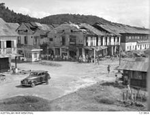
[28] At the later stages of the war, what remained of the town was destroyed again by Allied bombings day and night for over six months as part of the Borneo Campaign in 1945, leaving only three buildings standing.
[6] The war in North Borneo ended with the official surrender of the Japanese 37th Army by Lieutenant General Baba Masao in Labuan on 10 September 1945.
[29] After the war on the edge of bankruptcy, the British North Borneo Company returned to administer Jesselton but was unable to finance the huge costs of reconstruction.
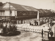
[32] On 22 December 1967, the State Legislative Assembly under Chief Minister Mustapha Harun passed a bill renaming Jesselton as Kota Kinabalu.
[32] Being the capital city of Sabah, Kota Kinabalu plays an important role in the political and economic welfare of the population of the entire state.
There are four members of parliament (MPs) representing the four parliamentary constituencies in the city: Sepanggar (P.171), Kota Kinabalu (P.172), Putatan (P.173), Tuaran ("P.176") and Penampang (P.174).
[38] On one end of the scale, Kota Kinabalu may sometimes only refer to, especially by local inhabitants, the city centre or central business district near the sea facing Gaya Island.
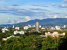
[6] The original local plant life has largely disappeared, but several hills within the city (too steep for building) are still clothed with tropical rainforest.
[41] The five islands (of Gaya, Sapi, Manukan, Sulug, Mamutik) opposite the city, and their surrounding waters, are also preserved as the Tunku Abdul Rahman National Park.
The city is growing steadily and the urban sprawl extends to the towns of Inanam, Menggatal, Sepanggar, Telipok and south of the district border to Penampang, Putatan, and Lok Kawi.
Non-Malaysian citizens form the largest group in the city with 110,556 people followed by Chinese (93,429), Bajau (72,931), Kadazan-Dusun (69,993), other Bumiputras (59,107), Malay[55] (35,835), Murut (2,518), Indian (2,207) and others (5,482).
[54] The Chinese are mostly Hakkas and reside mainly in the Luyang area as well as in Likas and Damai neighbourhoods with significant populations in other suburbs such as Manggatal, Inanam and Telipok.
The Bajaus, originally from Tuaran and Kota Belud, also have a significant presence in the city, along with other Bajau communities from various coastal regions of Sabah.
Additionally, there are several other indigenous groups, including the Murut, Suluk, Sungai, Lun Bawang/Lundayeh, Bisaya, Illanun, Kedayan, Ida'an and Rungus, who have relocated to the city for socio-economic opportunities from different parts of the state.
[57] The majority of Filipino migrants in the city come from the southern Philippines and the Sulu Archipelago, with notable communities of Chavacano speakers[58] and Bangsamoro background.
The mixed-race descendants are commonly referred to as Sino, with the term adapted to reflect the specific ethnic backgrounds of the parents, such as Sino-Kadazan, Sino-Dusun and others.
However, some find it difficult to speak fluently due to a limited vocabulary and the general lack of usage of the English language as a conversational lingua franca among Sabahans as a whole.
[26][67] It was built for the main purpose of transporting commodities from the Interior Division to the port in Jesselton (now Kota Kinabalu) during the period of British rule.
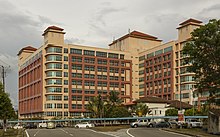
Its main campus is on a 999-acre (4.04 km2) piece of land, on a hill facing the South China Sea at Sepanggar Bay, about 10 kilometres north of the city centre.
With an area of 24 acres (9.7 ha), it is one of the few remaining patches of mangrove forest that once existed extensively along the coastal region of Kota Kinabalu.
[113] The weekly Gaya Street Sunday Market features a gathering of local hawkers selling a wide range of items from traditional ethnic cultural souvenirs to pets and flowers.
Among those who performed include Grupo Da Bossa, Gordon Horace Chin, Hady Afro, Joe Balanjiu Jr and La Sambusa Latina from Argentina.
[130] Several countries have set up their consulates in Kota Kinabalu, including Australia,[131] Brunei,[132] China,[133] Czech Republic,[134] Denmark,[135] France,[136] Finland,[137] Indonesia,[138] Japan,[139] Norway,[140] Panama,[141] Romania,[142] Slovakia,[143] South Korea,[144] Spain,[145] Sweden[143] and the United Kingdom.