Jog Falls
Sharavathi, a river which rises at Ambutirtha, next to Nonabur, in the Thirthahalli taluk, Shivamogga district takes a northwesterly course by Fatte petta, receives the Haridravati on the right below Pattaguppe and the Yenne Hole on the left above Barangi.
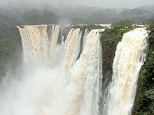
The Sharavathi, flowing over a very rocky bed about 250 yards (230 m) wide, reaches a tremendous chasm, 290 m (950 ft) deep, and the water comes down in four distinct falls, Raja, Rani, Roarer and Rocket.
Halfway down, it is encountered by the Roarer, which precipitates itself into a vast cup and then rushes violently downwards to meet the Raja.
The power station was previously named Krishna Rajendra hydro-electric project, after the King of Mysore at that time.
[20] The Power House on the right bank of the Gerusoppa dam consists of four Francis-type turbines coupled to the generating units of 60 MW each.
Power from the outdoor yard is evacuated through a 220 KV double circuit transmission line connected to the state grid at Talaguppa.