John McLaren Park
The then-governor of Mexico (including present-day California), Juan Bautista Alvarado, granted what is now known as John McLaren Park to the local authorities in 1840.
[7] Several areas in the original 550-acre proposed park area were used to build the School and Convent of the Good Shepherd of San Francisco (the school, which was operated from 1932 to 1977, was later known as University Mound High School and served 'delinquent' girls),[10] the Lick Home (later known as the University Mound Ladies Home, which opened as the Lick Old Ladies Home in a different location in 1884 and housed "elderly women of modest means" until 2014),[11] the University Mound reservoirs, the Sunnydale Housing Project, and the Crocker Amazon Playground.
A draft master plan was prepared in 1983, updated in 1988, and issued in 1996, following a 1987 bond passed by San Francisco voters to allocate $2.4 million for major park improvements.
In 1981, a San Francisco Examiner article headlined "McLaren Park: great potential, much trash" highlighted its crime statistics, which had included two murders, six rapes and 18 car thefts in 1980.
"[17] In 2013, the Chronicle's urban design critic John King discussed community efforts to revive the park, which "not long ago was known within the city primarily for crime".
[16] Perhaps due to its past infamy and resulting discouragement of visitors,[failed verification] the park boasts the largest grasslands left in San Francisco.
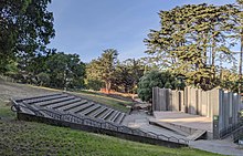
[26] It was co-designed by artists Peter Richards and Susan Schwatzenberg[2][27] and features fourteen stone markers by mason George Gonzalez intended as "musing stations" to stimulate contemplation.
It was completed in 1963[3] and had been used as a shortcut to Candlestick Point and occasional street-racing dragstrip,[17] but it was reconstructed as a two-lane road during the Mansell Street Corridor Improvement Project, a US$6,800,000 (equivalent to $8,740,000 in 2023) construction job lasting one year.
[28] One side of the road was rebuilt as a dedicated pedestrian and bicycle path, and crosswalks with bright flashing beacons were added to major intersections,[28] allowing foot traffic between the north and south halves of the park.
[3] The Wilde Reservoir Overlook, on the eastern edge of the park at the intersection of Mansell Street and Visitacion Avenue, was completed and opened to the public in 1981.
[22] The Wilde Reservoir was used to store tap water for the City of San Francisco, but after its abandonment, was used as a nocturnal dumping ground for trash.
[16] In the northeast corner of the park is Yosemite Marsh, a habitat for native species that include the forktail damselfly and flowering quillwort.
Named a "significant natural resource area" by the city in 1995, the marsh marks the origin of Yosemite Creek, a body of water that flows through underground culverts towards Candlestick Point.