Juan Bautista de Anza National Historic Trail
The trail was an attempt to ease the course of Spanish colonization of California by establishing a major land route north for many to follow.
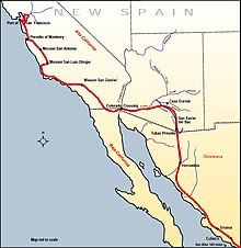
Juan Bautista de Anza led an exploratory expedition on January 8, 1774, with 3 padres, 20 soldiers, 11 servants, 35 mules, 65 cattle, and 140 horses set forth from Tubac Presidio, south of present-day Tucson, Arizona.
The friendly Quechan (Yuma) Indians (2,000–3,000) they encountered there were growing most of their food using irrigation systems and had already imported pottery, horses, wheat and a few other crops from New Mexico.
[4] The second group, under Fernando Rivera y Moncada, took an overland route over the Anza trail 1,200 miles (1,900 km) through the desert from Sinaloa Mexico.
On July 17–19, 1781, the Yuma (Quechan) Indians, in a dispute with the New Spain government and church, destroyed both missions and pueblos – killing 103 soldiers, colonists and Friars and capturing about 80 more (mostly women and children).
Included in the casualties were Fernando Rivera y Moncada military commander and former governor of California and Father Francisco Garcés founder of the missions on the Colorado River.
In four well-supported punitive expeditions in 1782 and 1783 against the Quechans, the Spanish managed to gather their dead and ransom nearly all the prisoners but failed to re-open the Anza Trail.
[5] According to historian David Weber, the Yuma revolt turned California into an "island" and Arizona into a "cul de sac", severing Arizona-California and Mexican land connections before they could be firmly established.
The National Park Service has developed a printed and online: Brochure Map for driving and guides for auto tours, hiking sections, and designated Historic sites, landmarks, and museums open to the public.