June 2008 Midwest floods
After months of heavy precipitation, a number of rivers overflowed their banks for several weeks at a time and broke through levees at numerous locations.
The upper Mississippi Valley experienced flooding in Missouri and Illinois as the region's estuaries drained the floodwater into the river.
On June 11, Illinois Governor Rod Blagojevich deemed Clark, Coles, Crawford, Cumberland, Jasper and Lawrence counties as disaster areas.
Levee breaks on June 10 flooded portions of Lawrence County near Lawrenceville, inundating a campsite and forcing the evacuations of 200 homes.
On the early morning of June 14, the town of Oquawka, Illinois, was evacuated, due to a levee breach along the swollen Iowa River.
The hospital had to remain closed for an extended period of time because of power outages, generator failures, and extensive flood damage.
Governor Mitch Daniels said the state is compiling its own thorough estimates, with total damages expected to top $1 billion.
The water flooded parts of the lower campus of Luther College, damaging athletic fields and the Regents Center.
Winneshiek County officials called this the worst flood to occur in Decorah since the current levee system was put in place in the 1940s.
U.S. Highway 61, five miles (8 km) south of the city, had been closed on the morning of June 13 due to the rising waters of the Skunk River.
Along the upper Turkey River, the historic towns of Spillville and Fort Atkinson experienced significant flooding, with damaged roads and bridge approaches.
[24] On June 12, a levee broke, a railroad bridge owned by the Cedar Rapids and Iowa City Railway was swept away along with loaded rail cars (which had been filled with rock in an attempt to keep the bridge in place, or failing that, cause it to sink to the bottom very close to its original location), 100 city blocks were submerged downtown, and 10,000 people were evacuated.
[25] In Waterloo, fast-moving water swept away a railroad bridge used to transport tractors from a John Deere factory to Cedar Rapids.
[23] The Black Hawk County Emergency Management Agency recommended the evacuation of the Cedar Terrace Neighborhood in Southeast Waterloo on June 10.
[31] The small town of Palo, just upstream from Cedar Rapids, and home of Iowa's only nuclear power plant, underwent a mandatory evacuation.
In days leading up to the State of Emergency, 8 to 11 inches (280 mm) of rain has fallen and winds have been recorded at 98 miles per hour across the area.
[41] There were major levees in Des Moines and Cedar Rapids that were breached which forced evacuations and caused extensive damage.
[42] On June 27, 2008, muskrat holes weakened a Mississippi River levee, allowing floodwaters to pour into Lincoln County, Missouri.
The rise in water levels begin as early as September and October leaving the county soil saturated as the grounds free along the Missouri River and continues to cause more property damage in the spring during cyclone season.
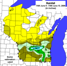
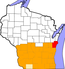
[48] Wisconsin Governor Jim Doyle declared a state of emergency in thirty counties on June 9 due to the flooding.
On June 9, water rushing out of the lake eroded a section of County Highway A and washed away three homes and tore apart several others.
The lake became nearly empty and the escaping flood water created a new channel for the Wisconsin River about a quarter mile away from the dam.
[52][53][54] In southwestern Wisconsin, the Kickapoo River rose several feet above flood stage, destroying most of the village of Gays Mills.
[55] Westbound lanes of Interstate 94 were closed between Johnson Creek and Lake Mills on June 10, 2008, at 7 pm because of the rising Rock River.
[66] On June 18, the President put five more counties under disaster area status, allowing Dodge, Green, Waukesha, Washington, and Winnebago.
In city or country, suburb or industrial area, the main public health hazard was the polluted water, mixed with the outflow of overwhelmed sanitary sewer systems, petroleum products and a variety of other toxic materials, to include asbestos.[where?]
As the waters recede, tremendous amounts of potentially infectious debris added to the problem; this included uncollected garbage and dead animals.
Even in adults, the stress of applying for services and managing daily activities under catastrophic conditions, along with the summer heat and number of people needing the same things, was expected to exacerbate pre-existing anxiety, depression, or family conflict.
"Once the original shock and dismay pass, the losses of such things as wedding photos or treasured family heirlooms can lead to depression and even post-traumatic stress disorder," said one official.
[72] Some rural areas suffered from a lack of access to badly-needed public and social services, and agencies were overwhelmed with the increase of people needing assistance.