June 2011 Christchurch earthquake
[8] A group of dextral strike-slip structures, known as the Marlborough fault system, transfer displacement between the mainly transform and convergent type plate boundaries in a complex zone at the northern end of the South Island.
Since the European settlement, the largest on record was a magnitude 8.2 ML major earthquake that occurred on 23 January 1855 near the Wairarapa plains of the North Island.
The magnitude 7.1 Mw event of 4 September 2010 produced by far the strongest ground motions ever recorded in the Canterbury region,[13] triggering a large number of aftershocks.
Although similar aftershock sequences have historically occurred around the world, such occurrences were extremely unusual in the region, which had shown low levels of seismic activity for thousands of years.
The event has led to the discovery of previously dormant geological faults across central-eastern South Island, in particular beneath regional plains and the adjacent seabed.
[15] The June earthquake was preceded by a magnitude 5.9 ML tremor with a similar focal mechanism that struck 1 hour and 20 minutes earlier.
[17] Weeks later, a magnitude 5.4 ML tremor jolted Christchurch overnight on 22 June, causing additional damage and prompting evacuations.
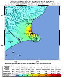
Maximum ground motions registered at VIII (Severe) on the Mercalli intensity scale in Christchurch, while strong shaking (MMI VI) was felt in adjacent populated areas such as Rolleston and Lincoln.
[3] The earthquake and the precursor tremor struck during the afternoon near a populated area, where most buildings had been left in precarious conditions by the February 2011 event.
The tremor had damaged 70 underground 11,000 volt cables, contributing to the outages,[26] and ruptured water mains, resulting in widespread street flooding.
[27] Several days after the tremor, dislodged electrical wiring from the ongoing aftershocks sparked a small fire in a control panel at Christchurch Hospital.
[31] In some parts of the Heathcote Valley, previously dormant or non-existent natural springs surfaced because of a sudden rise in the water table, flooding some properties.
The building had become structurally compromised due to its collapsed western wall, and the strong vibrations had shattered its stained glass rose window.
[44] The tower of the historic Lyttelton Timeball Station, which endured damage from the February 2011 earthquake, collapsed before dismantling work on the building could be completed.
[47] Artefacts from the Canterbury Museum collection were thrown into disorder by the aftershocks, several days after reordering work following the February 2011 earthquake had been completed.
Essential organisations in the area were evacuated as a safety precaution, including the police headquarters and offices of the Canterbury Earthquake Recovery Authority.
[31] Months before the event, a severe magnitude 6.2 earthquake occurred in a similar area adjacent to Christchurch, causing widespread destruction and fatalities in the city.