June 2012 North American derecho
The June 2012 Mid-Atlantic and Midwest derecho was one of the deadliest and most destructive fast-moving severe thunderstorm complexes in North American history.
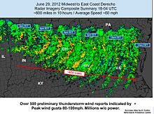
The storm started as a small thunderstorm cell in central Iowa and continued into Illinois, developing into a mesoscale convective system (MCS) while mostly below severe limits at the time.
[3] As the storm tracked eastward into Indiana, it became a derecho and wind gusts increased substantially, peaking as high as 91 mph (147 km/h) in Fort Wayne.
[5] Moving southeastward to east-southeastward at about 60 mph (95 km/h)—a speed and trajectory that the derecho maintained for its entire lifespan—it followed the stationary front and increased in size as it entered Ohio in the mid-afternoon hours, affecting a large portion of the state.
[6] It crossed over the Columbus area at approximately 5:00 p.m. EDT, with winds reported to 82 mph (132 km/h) there, and caused severe damage to the power grid in Franklin, Delaware, and Licking Counties.
[8] The derecho crossed the mountains of West Virginia, leaving destruction in its wake, as well as parts of southwestern Pennsylvania and eastern Kentucky through the early evening hours.
[10] As the derecho failed to weaken over the mountains, the moderate risk was expanded eastward by the SPC at 9:00 p.m. EDT (0100 UTC) into the mid-Atlantic region.
[7] Damaging winds continued eastward across the Chesapeake Bay towards the Atlantic Ocean, losing little strength despite the cooler marine layer.
[7] Numerous special marine warnings were issued for the coastal waters of affected states by the NWS as the derecho moved out to sea.
Its formation prompted the SPC to issue another severe thunderstorm watch, the second of the day for much of the region, for the areas in its path including parts of Iowa and Illinois.
[citation needed] Damage was widespread and extensive along the entire path of the derecho, especially in northern Indiana and the Fort Wayne metro area, central and western Ohio, northeastern Kentucky, southwestern Pennsylvania, West Virginia, northern, central, and southwestern Virginia,[15] Maryland, Washington, D.C., Delaware and southern New Jersey.
[19] As it occurred in the midst of the record Summer 2012 North American heat wave, conditions on following days were problematic, particularly for seniors and vulnerable people.
Saturday afternoon, Ohio Governor John Kasich declared a state of emergency due to widespread power loss, damages, and the ongoing heat wave.
Wind gusts with this derecho were closer to 85 mph (137 km/h), and, though of a significantly shorter duration, caused more damage to trees and power lines than Ike.
[22] In Bellefontaine, the storm's strength was sufficient to cause severe damage to the tower of the county courthouse,[23] a reinforced sandstone structure.
The American Red Cross shipped tens of thousands of meals to the state, along with large quantities of water to residents in entire communities that were isolated as a result.
Throughout the Northern Baltimore (city) area neighborhoods experienced disrupted traffic patterns as large trees felled by the storm blocked secondary arterial roadways.
[40] On July 19, 2012, President Obama declared three counties in New Jersey (Atlantic, Cumberland, and Salem) federal disaster areas.