Junggar Basin
[3] The basement of the basin was largely formed during the development of the Pangea supercontinent during complex tectonic events from Precambrian to late Paleozoic time.
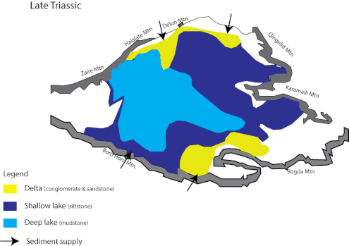
The layers continuously deposited fluvial and lacustrine facies until the present day, mostly containing conglomerate, sandstone, siltstone, and mudstone.
[1] The westerlies contained the lesser moisture that has come from the northwest since the marine areas gradually minimized to the recent Caspian Sea.
[16] Xinjiang paleocraton was pulled apart for a continental rifting episode to form extensional basins in Late Cambrian.
[17] The continuous divergence of the continental crust during late Cambrian to Ordovician shaped the West Junggar Ocean.
[17][12][4] Three plates (Tarim, Kazakhstan, and Siberian) converged together to form a trapped ocean that surrounded volcanic arc and orogens in Mid-Carboniferous.
The following cooling crustal episode led to part of the mountain belt sink by thermal subsidence, which ended up forming the Junggar Basin.
[22][11] This was forming heterogenic silica-rich igneous rocks due to the partial melting of numerous oceanic crusts contaminated with mantle wedge.
[23][3] Then, the area gradually became a mountain-trapped peripheral foreland basin due to high-temperature and relaxing subsidence from the regional extension.
[1][3][23] Some also suggested this landform caused by the combined effect of shearing and extension or thrusting from crustal shortening.
[1] There presented extensional shearing and continuous deposition of non-marine foreland basin-fill till Triassic.
[1] Afterward, the southward lake depression leading the basin centre shift to the south in the Upper Cretaceous period.
[1] At the same time, there was rapid uplift of Tian Shan since Himalayan orogeny formed by the collision between Indo-plate and Eurasian Plate.
[1] This developed an alluvial-rich delta system around shallow lakes with the clastic sediments influx from uplifted Tian Shan and the northern part of the basin.
[3][26] For Carboniferous oil and gas deposits in this area, they were moved upward and accumulated in the Permian period and Mesozoic era sandstones.
[25] Besides, Tian Shan Foredeep in the southern Junggar Basin (including Urumqi) is also available for the petroleum resources.
[26] The petroleum there were formed due to rapid subsidence, regional ductile with mobile intrusion, and cross-cutting on anticlines by orogenic activity (probably in Neogene) from the Tian Shan.
[3] Ore deposits in the Junggar Basin were mainly formed in the Paleozoic era which was related to tectonic development.