KNP Complex Fire
After lightning ignited the Paradise and Colony fires in the southern Sierra Nevada on September 9, the twin blazes combined into the Complex and burned a total of 88,307 acres (35,737 hectares).
The KNP Complex forced the communities of Three Rivers, Wilsonia, and Cedar Grove to evacuate, and caused the temporary closure of Sequoia and Kings Canyon National Parks while damaging roads, trails, and cabins within.
The fire also heavily impacted the endangered giant sequoia, which grows in less than a hundred natural groves in the western Sierra Nevada.
Prior to European-American settlement, frequent fires of lower severity occurred, leaving most sequoia trees unharmed and aiding regeneration in the forest by consuming dry fuels.
[13]: 290–292 Campgrounds and park roads nearby closed and suppression efforts began, with handcrews on the ground and water and fire retardant drops from the air.
The northern portion of the blaze pushed up and out of the Marble Fork into the Halstead Creek drainage in a 6,500-acre (2,600 ha) "extreme head fire run", according to a National Park Service post-fire assessment, burning the entirety of the Suwanee Grove at almost entirely moderate to high severity.
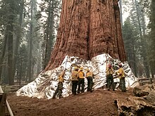
[31][13]: 292–294 The fire also entered the westernmost edge of the Giant Forest grove for the first time, in the vicinity of the Four Guardsmen trees,[32][31] but firefighters' protective efforts ensured all four survived.
[34] In late September, a high-pressure system settled in place over the area: higher humidity levels and lower temperatures, combined with a thick smoke inversion, stifled fire behavior somewhat even as the lack of visibility prevented aircraft from flying.
Despite this, on September 24, fire activity ticked up as flames moved down from the conifer forests into the grass and oak woodlands closer to the visitors center in the foothills, and leapt past firefighters and their control lines on Paradise Ridge.
[13]: 296 Redwood Mountain Grove was singled out for concern—park officials knew that its southern section lay on a steep slope and was littered with excess fuel.
Officials also decided to apply an experimental polyacrylamide fire retardant gel to the canopies of the giant sequoias, and some was dropped on trees in Muir Grove.
[39] Smoky conditions kept aircraft away from Redwood Mountain Grove, preventing gel drops there, and before long the wildfire outpaced the firefighters' burnout operations.
[13]: 296 The fire burned hot in the canyon, putting up 40,000-foot (12,000 m) convective pyrocumulus or pyrocumulonimbus clouds visible from the far side of the Sierra Nevada.
[49][50] Containment rapidly increased to 60 percent by October 21: with a total burned area of 88,307 acres (35,737 ha), this marked the end of the fire's expansion.
[51] On October 24, a significant atmospheric river made landfall in Northern California, delivering several inches of rain across much of the state.
Though it weakened as it slid southward,[52] two to three inches (51 to 76 mm) of rain fell on all parts of the fire and a flash flood watch was issued for the area.
[53][54] Christy Brigham, chief of resource management and science at Sequoia and Kings Canyon National Parks, declared it a season-ending event.
[3]: 9 Giant sequoias are typically resistant to wildfires, possessing thick bark and a canopy that grows well above the ground that protects them from smaller fires.
The Park Service assessment reported: "Much of the fire’s growth occurred due to backing and flanking, with short uphill runs.
However, in some areas terrain, fuels, and winds aligned to drive high intensity crown runs ranging from tens to hundreds of acres.
[60] Officials also wrote that protecting other threatened groves was the current priority and continued fire hazards precluded a complete assessment until later.
[61] In total, the National Park Service report estimated that the KNP Complex Fire killed between 1,330 and 2,380 large sequoias, defined as those over four feet (1.2 metres) in diameter.
The bill sought to provide $350 million over the course of a decade to codify the Giant Sequoia Lands Coalition (an existing partnership between federal, state, tribal and local land managers), create a reforestation plan for groves destroyed by wildfires, and streamline the environmental review process for thinning and removing vegetation from other groves.
Legislators working to draft the bill visited some of the worst-affected groves from the KNP Complex Fire in Sequoia National Park in May, prior to its introduction.
[66] Despite having 75 co-sponsors in the House, the bill was opposed by 81 environmental groups, including the Sierra Club, the League of Conservation Voters, Greenpeace, the Pacific Crest Trail Association, and Defenders of Wildlife.
[67][68][69] Their joint letter to Congress argued that the bill would "weaken existing environmental law to expedite potentially harmful logging projects that undermine the ecological integrity of sequoia groves and do nothing to protect these trees".
[75] In February 2023, the Park Service began seeking public feedback on replanting sequoia and conifer seedlings in several groves particularly affected by the KNP and SQF Complex fires.
[85] During winter storms in early 2023, fire-weakened hillsides contributed to washouts and damaged culverts, again causing multiple closures along the highway.
[13]: 59–72 In addition to giant sequoia mortality, the Burned Area Emergency Response (BAER) team evaluated a host of other environmental impacts from the fire.
Acreage reflects, where possible, the figure reported in the daily morning update following overnight aerial infrared mapping of the fire.