Kalchreuth
Kalchreuth is a municipality in the district of Erlangen-Höchstadt, in Bavaria, Germany.
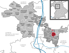
It is located 10 kilometers east of Erlangen and 15 kilometers north of Nuremberg and contains the villages of Kalchreuth, Käswasser and Röckenhof and also the hamlets of Stettenberg, Minderleinsmühle and Gabermühle.
In 1342 most of the estates were sold to the Patrician family Haller von Hallerstein in whose possession it was until 1465 and was later on taken over by the Free Imperial City of Nuremberg.
[3] The coat of arms of Kalchreuth is split in four parts of which the upper left one features an obliquely leaned silver and black chevron that was taken from the blazon of the Haller von Hallersteins.
The upper right quarter shows an armed black lion with a red crown on silver ground (retrieved from the Nuremberg Castle earl’s crest) while the nether left part shows a black saltire on silver ground and the nether right quarter shows a silver cherry blossom on red ground symbolizing the community’s location in one of the most popular Franconian cherry-growing area.