Kalorama Triangle Historic District
The neighborhood is roughly bounded by Connecticut Avenue to the west, Columbia Road to the east, and Calvert Street on the north.
The area was originally home to the Nacotchtank and Mattawoman tribes until the 17th-century when tracts of land were granted by Charles II of England.
The two neighborhoods were eventually divided by Connecticut Avenue, which runs north from Dupont Circle to Woodley Park via the Taft Bridge.
Before then, there were already three landmarks on the NRHP, including the Lothrop Mansion, the Fuller House, and the equestrian statue of George B. McClellan.
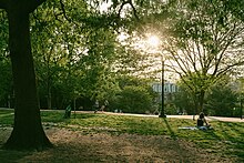
The cohesiveness of the buildings, the quiet streets, the diversity of the population, and the easy access to restaurants and Washington Metro stations are the major factors for people living in the neighborhood.
The surrounding neighborhoods are Adams Morgan to the north and east, Dupont Circle to the south, and Sheridan-Kalorama to the west.
[2][3] The neighborhood is sometimes referred to as part of Adams Morgan or the larger Sheridan-Kalorama Historic District, located on the west side of Connecticut Avenue.
[2][3][4] Kalorama Park is 3 acres (1.2 ha) and located between 19th Street, Columbia Road, and the rear properties on Mintwood Place.
[3] The land comprising modern-day Kalorama Triangle was originally inhabited by Native American tribes, including the Nacotchtank and Mattawoman.
[5]: 18 In the 1600s, Charles II of England gave one of his former servants an estate in modern day Washington, D.C. A portion of the 600 acres (240 ha) tract was later called Widow's Mite.
When the surrounding area was planned as the nation's capital in 1790, the land was included in Washington County, D.C.[5]: 16 There was a manor house called Belair that was built in 1795 on the former Widow's Mite estate.
There were 17 slaves owned by Little and his relatives, all of whom were freed in 1862, due to legislative actions by Senator Henry Wilson and President Abraham Lincoln.
Because of her brave attempt and due to the site where she lived, the Kalorama Park and Archeological District is a historic landmark and included in the National Underground Railroad Network.
[5]: 36 Construction of a new Woodley Lane Bridge over Rock Creek along with extending Connecticut Avenue northward spurred further interest in Kalorama Triangle.
[5]: 38–41 [6] This was due in part to the Panic of 1893 and Highway Act of 1893, which required L'Enfant Plan street layouts to be followed in the former Washington County.
[6] Around the turn of the century, Kalorama Triangle featured numerous large free-standing houses, including Managannsett, which stood at the intersection of Columbia Road and Wyoming Avenue.
It is one of 25 apartment buildings constructed in Kalorama Triangle between 1901-1927, mostly along Connecticut Avenue and Columbia Road due to access to streetcar lines.
[5]: 45 There were mostly small commercial properties built along Columbia Road and Calvert Street during the 1930s, which were the last undeveloped lots in the Kalorama Triangle.
[2] Many of the developers and architects that designed houses and apartment buildings in the neighborhood were prominent in their professions, including Arthur B. Heaton, Harry Wardman, B. Stanley Simmons, Hornblower & Marshall, James G. Hill, Appleton P. Clark Jr., and Thomas Franklin Schneider.
[11] Additional buildings and sites added to the DCIHS and NRHP include the Fuller House, the Lothrop Mansion, the Kalorama Park and Archeological District, and the statue of George B. McClellan.
[12] The mixture of historic buildings, quiet streets, easy access to area restaurants and grocery stores, and diversity of its population has drawn in residents for decades.