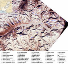
Karakoram
Most of the Karakoram mountain range is within Pakistan's Gilgit-Baltistan region, the northern subdivision of Kashmir.
The range is about 500 km (311 mi) in length and is the most glaciated place on Earth outside the polar regions.
[9][10] Later terminology was influenced by the Survey of India, whose surveyor Thomas Montgomerie in the 1850s gave the labels K1 to K6 (K for Karakoram) to six high mountains visible from his station at Mount Haramukh in Kashmir Valley, codes extended further up to more than thirty.
The Muztagh Pass was crossed in 1887 by the expedition of Colonel Francis Younghusband[12] and the valleys above the Hunza River were explored by General Sir George K. Cockerill in 1892.
The name Karakoram was used in the early 20th century, for example by Kenneth Mason,[9] for the range now known as the Baltoro Muztagh.
Floral surveys were carried out in the Shyok River catchment and from Panamik to Turtuk village by Chandra Prakash Kala during 1999 and 2000.
[22] In the last ice age, a connected series of glaciers stretched from western Tibet to Nanga Parbat, and from the Tarim basin to the Gilgit District.
[23][26] In the north, the Karakoram glaciers joined those from the Kunlun Mountains and flowed down to 2,000 metres (6,600 ft) in the Tarim basin.
Rudyard Kipling refers to the Karakoram mountain range in his novel Kim, which was first published in 1900.
Marcel Ichac made a film titled Karakoram, chronicling a French expedition to the range in 1936.
Greg Mortenson details the Karakoram, and specifically K2 and the Balti, extensively in his book Three Cups of Tea, about his quest to build schools for children in the region.