Karakoram fault system
The slip along the fault accommodates radial expansion of the Himalayan arc,[2] northward indentation of the Pamir Mountains,[3] and eastward lateral extrusion of the Tibetan plateau.
[6] The creation of the Karakoram fault started with the closing of the ancient Tethys Ocean seaway which once separated the two modern continents of Asia and India.
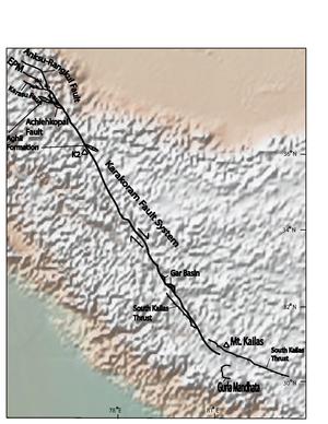
Currently some researchers believe that the Karakoram fault merges and terminates into the Indus-Yalu suture zone at Mount Kailas.
It terminates in the extensions of the Miuji Basin, in the Pamir Mountains, along the border between Tajikistan and Xinjiang provinces.
[10] Most people agree that the South-Eastern portion of the fault merges into and parallels the Indus Suture Zone in South West Tibet.
The southern segment of the Karakoram Fault shows that only 120 km of dextral motion is evident from offset of geologic features, such as the Indus River and the South Kailas Thrust,[1] and that the strain in this region is almost entirely accommodated for by a north–south shortening in the Himalaya, just south of the Indus Suture Zone.
[19] Exhumation along the Gurla Mandhata detachment, which is a low-angle normal-fault system, suggest that the faults have allowed for between 36 and 66 kilometers of slip.