Kardinya, Western Australia
Kardinya is a suburb 13 kilometres (8 mi) south-southwest of the central business district of Perth, the capital of Western Australia.
Before European settlement, the area was inhabited by the Beeliar group of the Whadjuk Noongar people, who had lived there for 40,000 years.
They lived in the area south from the Swan River down to Mangles Bay near Rockingham and east to the Darling Scarp.
All settlement was concentrated along the Swan and Canning rivers as they were the main method of transportation in the early decades of the colony.
[2]: 7 In 1870, fourteen smaller lots were excised from Cockburn Location 549 and were allocated to Pensioner Guards over 15 years.
To get the Pensioner Guards to stay in the colony, they were allocated land which they had to occupy for seven years before they could gain ownership.
The university did not end up using the land, but in 1922, it asked the Forests Department to police it for the illegal removal of timber.
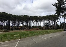
[2]: 16 [3]: 170 In 1924, the Bibra and North Lake Progress Association asked UWA and the Forests Department if part of the land could be used as a pine plantation.
In 1926, 382 hectares (945 acres) of land was cleared, and planted mainly with pinus pinaster, or maritime pine.
[2]: 47 In 1958, seven residents requested permission from the council to subdivide their land, however other people opposed this, wanting to retain the area's rural character.
This association was heavily involved in the development of Kardinya, providing input for planning schools, shopping centres, bus routes and community services.
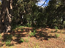
A small area on the eastern edge of the suburb lies on Bassendean dunes, which consist of white to grey sands formed between 800,000 and 125,000 years ago.
Other weeds were introduced accidentally, including Eragrostis curvula (African lovegrass), Ehrharta longiflora (annual veldtgrass), Polycarpon tetraphyllum (fourleaf allsead), Romulea rosea (Guildford grass), Trifolium campestre (hop clover), Euphorbia peplus (petty spurge), Carpobrotus (pigface), Plantago major (plantain), Lolium (ryegrass), Oxalis pes-caprae (soursob), Sonchus arvensis (sowthistle), and Ursinia.
[10] The most common ancestries that Kardinya residents identified with at the 2016 census were English (24.1%), Australian (19.0%), Chinese (8.4%), Italian (8.3%), and Irish (6.4%).
The next most common birthplaces were England (5.5%), Malaysia (2.8%), Italy (2.3%), China, excluding Taiwan and special administrative regions (2.1%), and Indonesia (2.0%).
The first business in the area was a corner store at the junction of what was then North Lake Road and South Street, established in the 1940s.
[2]: 58 In 1975, construction began on a shopping centre on the corner of the new North Lake Road alignment and South Street.
[2]: 61 The only other businesses in Kardinya are a small group of shops on the corner of Le Soeuf Drive and McMahon Way, and a light industrial area in the suburb's north-east.
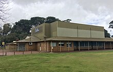
It was a committee member of the KJFC that started the push in 1979 for a community centre to be built at Morris Buzacott Reserve.
At first, the Melville City Council did not help with funding the proposed building, so a group was formed, called the Kardinya Community and Recreation Association.
This group, along with the Kardinya Residents Association continued to lobby for a community centre, and in 1985, the council finally approved its construction.
It was originally known as Somerville Lake but was renamed on 14 September 1983 in honour of J. F. Baldwin, who was a member of the Melville Roads Board from 1941 to 1944.
When Carawatha Primary School opened in 1959 on the corner of North Lake Road and Archibald Street in Willagee, students attended there.
A site was set aside on Ochiltree Way, and in June 1975, it was announced that a school would be built there, with an estimated cost of construction of $255,220.
[2]: 50–51 After opening, work continued on the school, including on the construction of the library, car park, bicycle racks, paths, sporting facilities and gardens.
[2]: 51–52 1984 saw the formation of a parent's consultative committee, a precursor to today's school councils which are common in Western Australia.
Some students who attended Wesley College in South Perth would cycle along North Lake Road to Canning Highway, then catch a bus there.
This was much closer to Kardinya, only a few kilometres north, making the journey to the nearest secondary school much shorter.
Both these districts are part of the South Metropolitan Region of the Western Australian Legislative Council (upper house).
Route 115 is a limited stop service that travels between Hamilton Hill and Elizabeth Quay bus station in the Perth CBD.