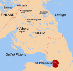
Karelian Isthmus
The Karelian Isthmus (Russian: Карельский перешеек, romanized: Karelsky peresheyek; Finnish: Karjalankannas; Swedish: Karelska näset) is the approximately 45–110-kilometre-wide (30–70 mi) stretch of land situated between the Gulf of Finland and Lake Ladoga in northwestern Russia, to the north of the River Neva.
According to the 2002 census, the population of the Kurortny District of Saint Petersburg and the parts of Leningrad Oblast situated on the Karelian Isthmus amounts to 539,000.
[4] The soil is predominantly podsol, which contains massive boulders, especially in the north and northwest, where large granite rocky outcrops occur.
Common vegetation of various types of pine forests includes heather, crowberry, common juniper, eared willow, lingonberry, water horsetail, bracken, graminoids (i.e. grasses in the wider sense) Avenella flexuosa and Carex globularis, mosses Pleurozium schreberi, Sphagnum angustifolium and S. russowii, and lichens Cladonia spp.
Prominent vegetation of various birch forests include meadowsweet, common wood sorrel, bilberry and graminoids Calamagrostis arundinacea and C.
Compared to other parts of the Leningrad Oblast, the winter here is usually milder due to the moderating influence of the Gulf of Finland, but longer.
The Karelian Isthmus is a popular place for hiking, cycling, skiing (Korobitsyno and Kavgolovo), climbing (near Kuznechnoye), canoeing (Losevo), fishing for consumption (of carp bream, northern pike, roach, European perch, ruffe, burbot and others), mushroom hunting (for porcini, red-capped scaber stalk, birch bolete, velvet bolete, slippery Jack, golden chanterelle, Lactarius resimus, woolly milk-cap, ugly milk-cap, saffron milk-cap, Lactarius rufus, various Russulas and others), berry picking (of bilberry, raspberry, woodland strawberry, cowberry, cranberry, cloudberry, bog bilberry and stone bramble).
It is a popular summer resort for Saint Petersburg citizens since the late 19th century, served by trains of Finlyandsky Rail Terminal.
In 1857 the canal was dug there, but the stream reversed direction, revealed rapids and rendered navigation at Kiviniemi impossible.
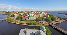
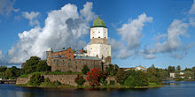
Apart from the old towns of Vyborg and Priozersk, and churches on the Konevets island of Lake Ladoga, since the late 19th century a number of other archaeological sites have been discovered on the isthmus.
There are many grave pits of Karelians of the 10th–15th centuries with metal and ceramic artifacts along the northern armlet of the Vuoksi, near Lake Sukhodolskoye and in a few other places in Priozersky District.
A few treasures of silver adornments and medieval Arabian and Western European coins have also been found, as the isthmus laid on the Volga trade route (at that time, the Vuoksi River had a distributary emptying into the Bay of Vyborg).
Due to its size, favorable climate, rich fishing waters and proximity to Saint Petersburg, the capital of the Russian Empire, the Karelian Isthmus became the wealthiest part of Finland once the Industrial Revolution had gained momentum in the 19th century.
[16] In November 1939, the Soviet Union staged the Shelling of Mainila and invaded Finland in what became known as the Winter War, which took a disproportionally heavy death toll on the Red Army.
[17] Finland ceded the Karelian Isthmus and Ladoga Karelia to the Soviet Union in the Peace of Moscow of 12 March.
On 31 March most of the ceded territories were incorporated into Karelo-Finnish SSR by a decision of the Supreme Council of the Soviet Union (in the Karelian Isthmus the districts of Jääski, Kexholm and Vyborg).
In the Battle of Tali-Ihantala, 25 June–9 July, the Finns concentrated their military strength and brought the offensive to a halt at the River Vuoksi, in the northwesternmost part of the isthmus, at the closest point only 40 kilometres from the border of 1940.
This time the ceded territories of the Karelian Isthmus (including the districts of Jääski, Kexholm and Vyborg) were incorporated into Leningrad Oblast (unlike Ladoga Karelia, which remained within the Karelo-Finnish SSR).
After the war the isthmus was included in the Leningrad Oblast and people from other parts of the Soviet Union, mostly Russians, were settled there.
[19] The Finnish toponyms of the territories included within Karelo-Finnish SSR and of the southern part of the isthmus (albeit assimilated) mostly remained.
The western part of the Karelian Isthmus is an important transport corridor linking Scandinavia and Central Russia.
Primorsk, terminus of the Baltic Pipeline System, which has recently become one of the most efficient Russian sea ports, is also located here.
The predecessor of the Priozersk facilities, Priozersky Pulp and Paper Mill, a major polluter of Lake Ladoga constructed in 1931, was closed down in 1986.
Northern and western parts of the isthmus are also an important reserve of granite (quarries in Kuznechnoye, as well as a number of others along the Vyborg-Hiitola railroad).
In Vsevolozhsky District state-owned Morozov Plant is located, which is an important producer of paints, adhesives, abrasives and other substances.
Bogs of Vsevolozhsky District along the shores of Lake Ladoga and the Neva River were major sources of peat for fuel.
In the northern part of Vsevolozhsky District, to the south of the old Finnish border, Karelian Fortified Region (KaUR) is located, which was reconstructed as late as in the 1960s, but now is abandoned as well.
There is Bobochinsky tank range (195.975 km², founded in 1913) between Kamenka and Kirillovskoye and a number of military facilities in Vsevolozhsky District in the lowlands between Lake Ladoga and Saint Petersburg-Hiitola railroad, including Rzhevsky artillery range (founded in 1879), a huge area, 740 km2 (286 sq mi), encircled by the Road of Life, the roads Rzhevka – Novoye Devyatkino and Novoye Devyatkino – Matoksa and the coast of Lake Ladoga (available to visitors since 2003).