Lake Eyre
The Lake Eyre Basin is a large endorheic system surrounding the lakebed, the lowest part of which is filled with the characteristic salt pan caused by the seasonal expansion and subsequent evaporation of the trapped waters.
The lake was formed by aeolian processes after tectonic upwarping occurred to the south subsequent to the end of the Pleistocene epoch.
[4] The −15 m (−49 ft) altitude usually attributed to Kati Thanda–Lake Eyre refers to the deepest parts of the lake floor, in Belt Bay and the Madigan Gulf.
[10] Due to the basin's low elevation below sea level and the region's high annual evaporation rate (between 2,500 and 3,500 millimetres (98 and 138 in)[11]), such schemes have generally been considered impractical, as it is likely that accumulation of salt deposits would rapidly block the engineered channel.
[12] At a rate of 1 cm (0.39 in) evaporation per day, a 3 m (9.8 ft) viaduct flowing a 0.5 m/s (1.6 ft/s) would supply enough water to create a 100 km2 (39 sq mi) sea.
[citation needed] The salinity in the lake increases as the 450 mm (18 in) salt crust dissolves over a period of six months of a major flood, resulting in a massive fish kill.
When over 4 m (13 ft) deep, the lake is no saltier than the sea, but salinity increases as the water evaporates, with saturation occurring at about a 500 mm (20 in) depth.
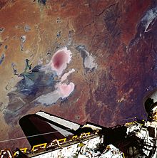
The lake takes on a pink hue when saturated, due to the presence of beta-carotene pigment caused by the alga Dunaliella salina.
However, owing to the very low rainfall in the lower reaches of these rivers (contrasting with heavy rainfall in the upper catchments),[17] the greater proportion soaked into the desert or evaporated en route to the lake, leaving less than 4 km3 (0.96 cu mi) in the lake, which covered an area of 800 km2 (309 sq mi), or 12% of the total.
[20] In late March 2019, floodwaters began arriving as a result of torrential rains in northern Queensland in January.
Traditional owners and graziers agree that it is essential that the river run its course and should not be harvested during floods, as any interference in the natural systems could damage the ecosystem.
[4] Birds such as pelicans and banded stilts are drawn to a filled lake from southern coastal regions of Australia, and from as far afield as Papua New Guinea.
[28] Scientists are presently unable to determine how such birds appear able to detect the filling of the lake, even when hundreds or thousands of kilometres away from the basin.
[31] Lake Eyre has been identified by BirdLife International as an Important Bird Area (IBA) known as the Lake Eyre Important Bird Area, because, when flooded, it supports major breeding events of the banded stilt and Australian pelican, as well as over 1% of the world populations of red-necked avocets, sharp-tailed sandpipers, red-necked stints, silver gulls and Caspian terns.