Kavousi Vronda
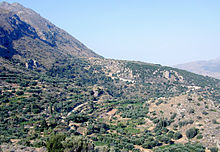
[1] It is situated in the northern foothills of the Thripti Mountains overlooking the Gulf of Mirabello, at an elevation of 427 m above sea level.
"Vronda" ("Thunder Hill"), as it was called by the pioneering archaeologist Harriet Boyd [Hawes] at the beginning of the 20th century,[2] is a local toponym; the entire ridge and surrounding area are also referred to as "Xerambela" ("Dry Vineyards"; Greek: Ξεράμπελα).
"[19] Boyd uncovered a large "house" with storerooms (now designated Building A-B) on the summit, an "excellent stretch of wall"[20] (now called the East Terrace Wall), and eight small tholos tombs (now labeled Vronda I–VIII) on the north and northwest sides of the ridges.
Coulson (University of Minnesota; later, American School of Classical Studies at Athens) to establish the Kavousi Project, which began with mapping of the site, a study of material found by Boyd and Sekadakis and housed in the Herakleion Archaeological Museum and the Archaeological Collection of Ierapetra (1979), cleaning of the tholos tombs (1981), a topographical plan, cleaning and drawing of architectural remains on the Vronda ridge (1983–1984), and two study seasons (1985–1986).
Full-scale excavations under the auspices of the American School of Classical Studies at Athens and the 24th Ephorate of Prehistoric and Classical Antiquities of the Greek Archaeological Service, and with permission from the Greek Ministry of Culture, were conducted from 1987 to 1990 and in 1992, followed by site conservation from 1993 to 1996, and study from 1990 to 2003.