Kaweah River
It then flows in a southwest direction to Lake Kaweah – the only major reservoir on the river – and into the San Joaquin Valley, where it diverges into multiple channels across an alluvial plain around Visalia.
[5][6] An informant for Latta, Aida Icho, provided an idiom related to the allegedly quarrelsome nature of the (by then extinct) Kaweah: Gawea been gone long time.
The Marble Fork begins in a high plateau area known as the Tableland and drops 1,200 feet (370 m) over a glacial headwall, forming Tokopah Falls, before flowing west past Lodgepole Village and turning south.
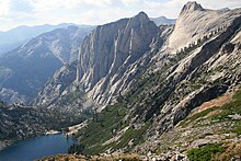
[9] The two forks join at the bottom of a deep gorge directly below Moro Rock to form the main stem of the Kaweah River.
A short distance outside Sequoia National Park it picks up the East Fork, which originates above 9,000 feet (2,700 m) elevation in the Mineral King valley,[11] from the left.
[10] It continues past the town of Three Rivers, where it receives the North Fork, which begins in the Grant Grove area of Kings Canyon National Park.
The South Fork enters from the left before the river empties into Lake Kaweah, the reservoir formed by Terminus Dam in the Sierra Nevada foothills.
[13] At the McKay Point Dam, the St. John's River splits off to the northwest, making a wide loop around Visalia before becoming Cross Creek north of Goshen, from where it flows south.
The length of the Kaweah River is 33.6 miles (54.1 km) between the confluence of the Middle and Marble Forks and the bifurcation of Mill and Packwood Creeks.
[19] Due to its steep fall from the Sierra Nevada to the San Joaquin Valley, the Kaweah River passes through a wide range of climate and vegetation zones in a relatively short distance.
Historically, the lower Kaweah flowed into a vast area of seasonally flooded wetlands surrounding Tulare Lake, almost all of which have been diked and drained for agriculture.
The foothill zone is characterized mostly by grassland and rangeland; California oak woodland occurs along the Kaweah River and its perennial tributaries, although its range has been much reduced since Native American times.
[22][23] A relatively small portion of the Kaweah basin is high, craggy alpine country typical of the southern Sierra; such treeless, lake-studded areas of exposed granite are mostly found along the crest of the Great Western Divide.
[25] The Wukchumni spent summers hunting game and gathering herbs along the East Fork, and they traded with the Paiute peoples of the Great Basin.
[24] Oak trees grew in abundance along low-elevation, permanent streams and provided the staple food of acorns, which were used to make cakes and bread.
Permanent winter settlements in the foothills consisted of pit houses thatched with tules (vast amounts of which once grew in the marshes of the Kaweah delta) up to 31 feet (9.4 m) in diameter.
[29]: 15 The one resource extraction industry that succeeded in the Kaweah basin was timber; many logging camps sprang up in the heavily forested western slopes of the Sierra, including in the watershed's sequoia groves.
[34]: 30–32 In addition, multiple channels had to be dug to redirect the flow of St. John's River back into the Kaweah, which had been blocked by sediment during the 1862 flood.
The Wright Act allowed the formation of the Tulare Irrigation District, which began to establish a network of canals across the Kaweah Delta.
[35]: 144 In the 1960s Disney proposed to construct a ski resort in Mineral King, which would have brought one of the most intense developments in the history of the upper Kaweah watershed.
The resort would have included 22 ski lifts, a 1,030-room hotel, ten restaurants, and a railroad along the canyon of the East Fork Kaweah River to transport visitors from a parking area further down the mountain.
[36][37] In order to make the Kaweah Delta suitable for agriculture and eventually urban development, the tangle of diverging seasonal channels and marshes had to be drained and diked extensively.
[39] Today, the Kaweah Delta has very little resemblance to historic times; most of the streams have either disappeared or been channelized, and Tulare Lake itself is now a dry, diked basin that only very occasionally floods.
[49] However, the capacity of the reservoir, Lake Kaweah, was too small to control the most severe floods,[50] and was so for many years until the completion of a spillway enhancement project in 2004.
[51] Six huge fuse gates, the largest of their type in the world, were added to the dam; the reservoir can now safely hold 185,600 acre-feet (228,900,000 m3) of water, an increase of 30 percent from the original capacity.
[54] The river is free-flowing above Lake Kaweah so the rafting season depends entirely on the natural snowmelt, typically between April and July.
The upper South Fork in Sequoia National Park has good fishing for wild rainbow trout, although a long hike is required to reach it.