Great Rift Valley, Kenya
The Great Rift Valley is part of an intra-continental ridge system that runs through Kenya from north to south.
[1] It was formed on the "Kenyan Dome", a geographical upwelling created by the interactions of three major tectonics: the Arabian, Nubian, and Somalian plates.
[3] The Tugen Hills to the west of Lake Baringo contain fossils preserved in lava flows from the period 14 to 4 million years ago.
Menengai is a massive shield volcano in the floor of the rift with a caldera that formed about 8,000 years ago.
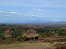
Further south the Mau Escarpment is a steep natural cliff approximately 1,000 m (3,300 ft) high, running along the western edge of the Great Rift Valley about Lake Naivasha.
The Aberdare Range forms a section of the eastern rim of the Great Rift Valley to the north of Nairobi.
Ngong Hills are peaks in a ridge along the east of the Great Rift Valley, located southwest near Nairobi.
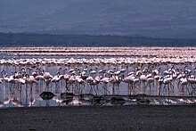
They have waters that are rich in blue-green algae, which feed insect larvae, small crustaceans and lesser flamingos.
Their numbers cause trampling of the silts in certain areas, while the feeding grounds are oxygenated due to probing beaks in the mud.
[14] Trona, an evaporative mineral, used for sodium carbonate production, has been mined at Lake Magadi for nearly 100 years.
[17] The Kenya lake system is a key location on the West Asian-East African Flyway, a route followed by huge numbers of birds in their annual migration from breeding grounds in the north to wintering places in Africa.
The lands around the lakes include large populations of black rhino, Rothschild's giraffe, greater kudu, lion, cheetah and wild dogs.
The Kenya lake system is surrounded by the steep escarpment of the Rift Valley, which provides a spectacular backdrop.