Khabarovsk
Khabarovsk (Russian: Хабаровск [xɐˈbarəfsk] ⓘ) is the largest city and the administrative centre of Khabarovsk Krai, Russia,[2] located 30 kilometers (19 mi) from the China–Russia border, at the confluence of the Amur and Ussuri Rivers, about 800 kilometers (500 mi) north of Vladivostok.
[5] The city was the administrative center of the Far Eastern Federal District of Russia from 2002 until December 2018, when the status was given to Vladivostok.
It is usually thought that the first such camp in the general area of today's Khabarovsk was the fortified winter camp named Achansk (Ачанск) or Achansky gorodok (Ачанский городок), built by the Cossacks of Yerofey Khabarov in September 1651 after they had sailed to the area from the upper Amur.
[21][22] On October 8 the fort was unsuccessfully attacked by joint forces of Achans and Duchers (who had good reasons to hate the Cossacks, due to their rather heavy-handed tribute-extraction tactics[23]), while many Russians were away fishing.
[22] In late November, Khabarov's people undertook a three-day campaign against the local chief Zhakshur (Жакшур) (whose name is also known in a more Russian version, Zaksor (Заксор)), collecting a large amount of tribute and announcing that the locals were now subjects of the Russian Czar.
A similar campaign was waged later in winter against the Ducher chief Nechiga (Нечига), farther away from Achansk.
[22] The exact location of Khabarov's Achansk has long been a subject for debate among Russian historians and geographers.
[23][24] A number of locations, both upstream and downstream of today's Khabarovsk, have been proposed since Richard Maack, one of the first Russian scholars to visit the region, identified Achansk in 1859 with the ruins on Cape Kyrma, which is located on the southern (Chinese) shore of the Amur, upstream of Khabarovsk.
[24] After the Treaty of Nerchinsk (1689) between the Tsardom of Russia and the Qing Empire, the area became an uncontested part of China for the next century and a half.
Modern historical maps of the Qing period published in China mark the site of future Khabarovsk as Bólì (Chinese: 伯力).
[25] French Jesuits who sailed along the Ussuri and the Amur Rivers in 1709 prepared the first more or less precise map of the region.
According to them, the indigenous Nanai people were living on the Ussuri and on the Amur down to the mouth of the Dondon River (i.e., in the region including the site of the future Khabarovsk).
[5] In 1894, a department of the Russian Geographical Society was formed in Khabarovsk and to found libraries, theatres and museums in the city.
[25] Chinese Emperor Puyi, captured by Soviet troops in Manchuria, was relocated to Khabarovsk and lived there from 1945 up to 1950, when he was returned to China.
In 1976 the city hosted an international ice hockey tournament with the ball for the prize of the newspaper Sovietskaya Rossia.
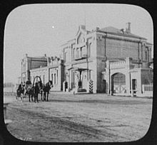
In 2008, the train station was completely renovated, and the adjacent square was reconstructed to include fountains and an underground passage.
Due to high summer humidity, overnight lows remain mild to warm during several months.
[25] The city's extreme climate sees daily average high and low temperatures vary by around 50 °C (90 °F) over the course of the year.
[12] Ethnic composition (2010):[38] Primary industries include iron processing, steel milling, Khabarovsk shipyard, Daldizel, machinery, petroleum refining, flour milling, pharmaceutical industry, meatpacking and manufacturing of various types of heavy and light machinery.
Transborder travel to China in winter ice road in summer boat on Amur river to Fuyuan (and train to Harbin) In 2021, the construction of a paid high-speed bypass of the city was completed.
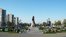
[41] There is a walking tour from the Lenin Square to Utyos on Amur via Muravyov-Amursky Street, where visitors find traditional Russian cuisine restaurants and shops with souvenirs.
Unlike Vladivostok, the city has never been closed to foreigners, despite it being the headquarters of the Far East Military District, and retains its historically international flavor.
Aleksandr Fedosov, the Khabarovsk Krai Minister of Culture, estimates that the city became more attractive to tourists following the 2015 Bandy World Championship.
[42] Khabarovsk is the closest major city to Birobidzhan, which is the administrative center of the Jewish Autonomous Oblast, Russia, located on the Trans-Siberian Railway, close to the border with China.
[citation needed] The headquarters of the Russian Ground Forces's Eastern Military District is located at 15 Serysheva Street.
[42] A delegation from the 2022 Winter Olympics organising committee visited Khabarovsk to watch matches in the bandy league to study the plans if the sport was to be added to the Games program.