Khirbet Tibnah
Khirbet Tibnah (also Tibneh[1]) is a tell (archaeological mound) located in the Ramallah and al-Bireh Governorate of the West Bank, between the villages Deir Nidham and Nabi Salih.
The earliest inhabitation at Khirbet Tibnah dated to the Early Bronze Age,[3] a period spanning approximately 3300–2000 BC.
[5] According to Eusebius' Onomasticon, which was written in the 4th century, the tomb of Joshua was in his time still visited at a place near the village.
[13] In 1596, the Tibnah (Tibya) site was listed as village in the nahiya Quds, in the administrative district Liwā` of Jerusalem, in a tax ledger of the "countries of Syria" (wilāyat aš-Šām) and which lands were then under Ottoman rule.
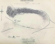
[17] Khirbet Tibnah is described in 1882 as a tell overlooking a deep valley (Wady Reiya) on the north and the ancient Roman road to the south.
A cemetery was situated on a flat hill nearby, and to the northwest, the spring of Ein Tibnah emerged from a rocky channel.
[15] British soldier Claude Reignier Conder survey Khirbet Tibnah on behalf of the Palestine Exploration Fund in 1873.
The local Palestinian populace objected on the basis that the project was taking place on land owned by Bassem Tamimi and sought legal help.