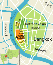
Rattanakosin Island
[1] It is bordered by the Chao Phraya River to the west and various canals to the east that were dug to serve as moats for what was originally the fortified city center.
Situated on the eastern convex bank of a meander in the Chao Phraya River, the island is the site of the Grand Palace and Bangkok's City Pillar Shrine, among other places of historical significance.
[2] King Phutthayotfa Chulalok (Rama I) founded the city as the capital of his new Rattanakosin Kingdom in 1782.
The old city straddled the Chao Phraya, but was mainly settled on the western bank where the royal palace and other institutions were situated.
Fortifications were ordered to be rebuilt, and canals extended to form moats around the fortified city.