Kilbeggan
Kilbeggan (Irish: Cill Bheagáin, meaning 'church of Bécán')[2] is a town in County Westmeath, Ireland.
Kilbeggan is surrounded by the gently rolling Esker Riada, the linear sand hills that stretch across the Irish midlands, which were left by retreating glaciers at the end of the last ice age.
The N6 - the main route between Dublin and Galway - originally passed through Kilbeggan, meeting the N52 in the town centre.
However, the location and full plan of the monastery were uncovered by geophysical survey by Archaeological Projects in 2003 west of the early-medieval graveyard (Hayden 2003).
A ford crossing the River Brosna at Kilbeggan was the site, in 972, of a battle between the Danes and the Irish.
[4] A skirmish led by the United Irishmen took place in the town, as part of the Irish Rebellion of 1798[6] The Lambart family came to be politically dominant in the midlands.
They firmly established themselves in and around Kilbeggan, gradually replacing the Geoghegan Family who were the leaders of Moycashel and the formidable Irish of (West) Meath Alliance who kept the English of (East) Meath in check from the Norman Invasion through the War of the Three Kingdoms, during which they sat as members for the two county Westmeath boroughs, and after The Restoration were restored to some land up to the ultimate defeat of the Irish by William and Mary's forces and allies and the Treaty of Limerick.
At payback time Lambart was charged with curbing the intransigent Geoghegans and their allies and was subsequently granted plan for a model Tudor 700 acres (2.8 km2) of land and 60 houses.
Rostella (Rosdalla), 3 km south of Kilbeggan is the site of the earliest recorded tornado in Europe, which occurred on 30 April 1054.
The town serves as a service centre for the local farming community; hosts some light industry, including sand and gravel extraction in the surrounding area.
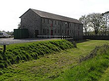
Although whiskey production ended at Locke's Distillery in the 1950s, the buildings survived and were reopened as a visitor attraction.