King's Park, Glasgow
It is situated south of the River Clyde and borders the Glasgow areas of Croftfoot, Cathcart, Simshill, Mount Florida and Toryglen and the neighbourhood of Bankhead in the adjoining town of Rutherglen.
King's Park is a residential area first developed for housing around 1930[1][2] a short time after the territory, historically within the civil parish of Cathcart in Renfrewshire,[3] was brought into the city of Glasgow, and retains much of the same appearance in the 21st century.
[citation needed] In 2007, residents of the cottage flats in the area were told they would not be entitled to the substantial council tax refunds which had been awarded to householders in almost identical properties in neighbouring Croftfoot, as theirs was considered a more affluent part of the city and consequently the higher payment 'band' applied was correct.
There is another green space on the north-facing side of the same incline at Ardmay Crescent which overlooks Scotland's national football stadium Hampden Park, the Toryglen district and the wider Glasgow urban area.
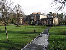
[2][1][9][10] The estate, featuring a walled flower garden, stone sundial and centuries-old trees came into the ownership of the MacTaggart & Mickel housebuilders at the time of the district's construction as a residential suburb, and was donated by them for use as a public park in 1930.
[18] Opposite the churches is a row of convenience stores, cafes and a post office, formerly a small public library (on the Rutherglen side of the local authority boundary so operated by South Lanarkshire Council) which closed in 2010,[19] and the site of the State Cinema, later a bingo venue, which was a prominent landmark in the area from the 1930s until its demolition in the early 21st century.