King George Sound (Western Australia)
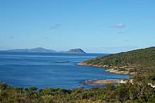
[4] The sound covers an area of 110 square kilometres (42 sq mi) and varies in depth from 10 to 35 metres (33 to 115 ft).
[12] During the course of their stay the ship's naturalist François Péron, collected 1060 new species of shellfish and a large number of starfish from the sound.
[13] Phillip Parker King visited the sound in 1818 aboard the cutter HMS Mermaid[14] while en route to conduct a nautical survey of the North West Cape,[15] and Frenchman Dumont d'Urville visited it in 1826 aboard the Astrolabe.
On 25 December 1826, the New South Wales colonial government brig Amity, under the command of Major Edmund Lockyer, arrived at King George Sound to establish a possessory military settlement.
In 1832, Governor of Western Australia Captain (later Admiral) James Stirling declared the settlement a town and renamed it Albany, but the broader locality continued to be referred to as King George's Sound for many years.
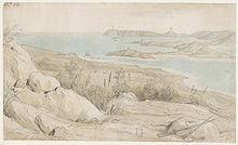
[22] In 1834 Robert Dale published in London a panorama print of the view from Mount Clarence accompanied by a pamphlet describing the sound and the geography, geology, flora, fauna and native inhabitants of the immediate region.
[23] On 8 March 1836, HMS Beagle visited King George Sound and anchored there for eight days.
These were then transported to Perth and Fremantle by road or coastal shipping until the early 1890s, when the completion of the Great Southern Railway provided a quicker service.
In 1978 the Cheynes Beach Whaling Company closed down after increasing environmental lobby group pressure.
[28] Installation of a shark barrier was commenced and completed in March 2016 at Middleton Beach[29] at the north western end of the sound.
Dense seagrass beds still exist in King George Sound, although they have been adversely affected by increased nutrient levels and industry in the area.
The sound comprises a wide variety of habitats that supports an abundance of marine life.
[46] King George Sound includes many islands and some islets, all comprising granitoid rocks with accumulations of soil on most.
The salinity level within the Sound remains relatively constant ranging between 34.8 and 35.5 '‰',[50] the lower levels occurring during heavy winter rain events when large volumes of freshwater enter the sound from the King and Kalgan rivers.
[51] The region of King George sound was featured in Kim Scott's 2010 novel, 'That Deadman Dance', which describes interaction and colonialism in 'the friendly frontier'.
[52][53] The former whale chaser Cheynes was sold for scrap in 1961 and was subsequently sunk between Michaelmas Island and the northern shoreline of the sound.
Another chaser in the fleet, Cheynes II, was blown ashore on Geak Point near Quaranup in Princess Royal Harbour in 1990 and is still there, approximately 290 metres (951 ft) off-shore.
[56] A Hobart wooden barque, the Fanny Nicholson was being used as a whaling vessel when it ran ashore during a gale in 1872.
Another Tasmanian whaling barque, the Runnymede, met a similar fate when it ran aground during a storm in 1881.
[58] In 1868, Northumberland, a wooden barque laden with 2000 tonnes of coal, grounded on a reef off Bald Head near the entrance to King George Sound.