King Island (Tasmania)
The island forms part of the official land divide between the Great Australian Bight and Bass Strait, off the north-western tip of Tasmania and about halfway to the mainland state of Victoria.
It was named after Philip Gidley King, Colonial Governor of New South Wales, whose territory at the time included what is now Tasmania.
King Island was originally part of a land bridge linking Tasmania with the Australian mainland, which was submerged around 12,000 years ago due to rising sea levels.
[citation needed] Captain Reed is the first known European to discover King Island in 1799 while hunting seals in the schooner Martha.
Baudin still circumnavigated and extensively mapped the island in 1802, giving French names to some localities that are still in use today like "Phoques Bay" on the north-west coast.
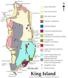
The other localities of King Island are Bungaree, Loorana, Lymwood, Nugara, Pegarah, Reekara, Sea Elephant, Surprise Bay, Wickham and Yarra Creek.
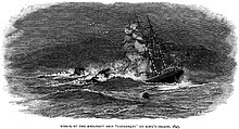
Situated in the centre of the western entrance to Bass Strait, King Island has been the location of more than 60 known shipwrecks, involving the loss of more than 2,000 lives.
[14] Notable shipwrecks include: Currie, the largest town and administrative centre, is situated on the west coast of the island.
In recent years the Grassy population has increased again and consists of local families, sea-changers, a campus of Ballarat Clarendon College and holiday makers.
Sitting partially submerged on the seabed, the Uniwave 200 will use oscillating water column technology to push air into a chamber fitted with an electricity-generating turbine.
[16] The village of Naracoopa is situated on the east coast about 20 kilometres (12 mi) from Currie and is known for its beach, jetty (fishing), holiday accommodation and eateries.
Naracoopa was the chief bulk fuels port and depot and is the site of a mineral sands deposit from which rutile, zircon and ilmenite were extracted between 1968 and 1977.
It is a safe harbour for passing yachts and the site of the Huxley Hill Wind Farm operated by Hydro Tasmania.
Although numerous bones have been found, the only existing skin was collected by Nicolas Baudin in 1802, shortly before the species became extinct, probably as a result of hunting by sealers for food.
[20] The IBA supports significant numbers of hooded plovers, flame robins and fairy terns, more than 1 per cent of the world populations of short-tailed shearwaters, pied and sooty oystercatchers, black-faced cormorants and pacific gulls, as well as populations of ten bird species endemic to Tasmania, including seven subspecies endemic to King Island.