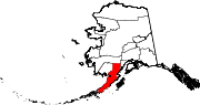
King Salmon, Alaska
King Salmon is a census-designated place (CDP) in Bristol Bay Borough in the U.S. state of Alaska.
Temperatures, especially extreme ones, are much less moderate than in the subpolar oceanic climate of the Pacific Ocean side of the Alaska Peninsula; however, average temperatures in winter are still milder than some locations in the coterminous United States, such as Fargo, North Dakota.
The town lies just below the southern limit of sporadic permafrost in Alaska, and is strongly sheltered from the extremely wet Aleutian Low which drops most of its moisture on the opposite (eastern) side of the mountains.
It is a lot colder than fellow west-coast climates of Europe on the same latitude due to the influence of the Siberian High on Bering Sea surface temperatures.
In summer, King Salmon catches up to similar latitudes in the British Isles, where the difference is much stronger in winter.
The area remains quite a bit colder year round than around the Baltic Sea in a similar west-facing location.
In the 1940s and 1950s, the U.S. Army Corps of Engineers constructed a 25 km (16 mi) long road from King Salmon to Naknek.
Other government agencies, such as the National Park Service, Alaska Department of Fish and Game, and the United States Weather Bureau, built facilities at King Salmon.
In 2010, a local National Weather Service employee and his wife were involved in a domestic terrorism plot that had proceeded to the operational phase.