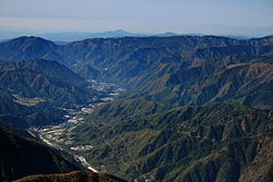
Kiso Valley
It is a v-shaped valley with length of approximately 60 km (36 mi) that follows the river as it flows from north by northwest to south by southwest into Gifu Prefecture.
[1] Through much of Japan's history, the Kiso Valley was used to connect the former Mino and Shinano provinces.
Since the Meiji period, the Chūō Main Line (for trains) and Route 19 (for vehicles) have been cutting through the valley.
In addition, the Kiso River excavation business was promoted, making it possible to transport large amounts of timber.
It was designated as a national forest in 1947, after World War II and went under the jurisdiction of the Forestry Agency.