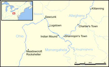
Kittanning (village)
[1]: 183 Together with Logstown, Pickawillany, Sandusky, and Lower Shawneetown, Kittanning was one of several large multiethnic and autonomous "Indian republics" made up of a variety of smaller disparate social groups: village fragments, extended families, or individuals, often survivors of epidemics and refugees from conflicts with other Native Americans or with Europeans.
[4] Kittanning served as a staging area for Delaware and Shawnee raids on British colonial settlements during the French and Indian War, until Pennsylvania provincial troops under the command of Colonel John Armstrong destroyed the village on 8 September 1756.
[1]: 308 The village was initially settled in 1724 by Delaware (Lenape) of the Turtle (Pùkuwànku) and Turkey (Pële) clans[8]: 43 [1]: 182 who were relocating westward due to pressure from expanding European settlements near Shamokin.
"[1]: 183 [9] By 1727, Pennsylvania traders including Edmund Cartlidge, Jonah Davenport, and James Le Tort, along with others, were trading at the Allegheny, with headquarters on the "Kythenning River".
"[12]: 51 The population grew as groups of Lenape, Cayugas, Senecas, and Shawnees migrated west into the Ohio River Valley seeking to escape a smallpox epidemic in 1733 and a drought in 1741, creating a multi-ethnic community.
In a report written 1 October 1728, the Marquis de Beauharnois, Governor of New France, wrote that the Nation of the Chaouanons (Shawnees) In a deposition made by James Le Tort and Jonas Davenport at Philadelphia on 29 October 1731, they stated that they had ... lately come from Allegeney, where there are Indian settlements consisting of about three hundred Delawares, two hundred and sixty Shawnees, one hundred Asswekalaes, and some Mingoes ... and that ... a French gentleman, in appearance, came down the river to a settlement of the Delaware Indians on the Ohio River, which the Delawares call Kithanning, with an intention ... to enquire into the numbers of English Traders in those parts, and to sound the minds of the Indians.
"[1]: 309–310 They also petitioned that "no trader above-mentioned may be allowed to bring more than 30 Gallons of Rum, twice in a year and no more", as excessive drinking was starting to have social and economic effects on the Shawnee people.
Through his interpreter Philippe-Thomas Chabert de Joncaire, Céloron told them, "I come only to speak to the nations of the Beautiful River (the Ohio), to animate the children of the (French) government which inhabit it."
We had to tan leather to make shoes (moccasins), to clear land, to plant corn, to cut down trees, to build hutts, to wash and cook.
[23]The map states that the village was "200 perches in length", (about 1005 meters or 3,300 feet) and labels the homes of Shingas (separated from the village on the north bank of the river), Captain Jacobs, Pisquetomen, King Beaver (Tamaqua), John and Joseph (Jo) Hickman, and "Bill's House" (the home of Bill Hickman), as well as a cornfield and a "long house, 30 feet, where frolicks and war dances are held."
The map depicts 40 houses, grouped according to clans, set in an arc overlooking the fields,[39]: 188 and shows the town as situated to the south of the Allegheny River and to the west of Cowanshannock Creek.
[23] In August, Lieutenant Colonel John Armstrong (brother of Fort Granville's commander) led 300 Pennsylvanian provincial troops[40]: 161 on the Kittanning Expedition, attacking and destroying the village on 8 September 1756.
Robert Robinson's eyewitness account of the battle says that Captain Jacobs barricaded himself and his wife and son inside his cabin, which appears to have been a European-style home with a "garret or cock loft window" from which he attempted to escape after it was set on fire by the Pennsylvanians.
[40]: 163 Armstrong described the ... vast Explosion of sundry Bags and large Cags of Gunpowder wherewith almost every House abounded, the Prisoners afterwards informing that the Indians had frequently said they had a sufficient Stock of Ammunition for ten Years War with the English.
With the Rooff of Capt Jacob's House when the Powder blew up, was thrown the Leg & Thigh of an Indian with a Child of three or four Years old such a Height that they ... fell in the adjacent Corn Field.
In August, 1763, a force of Delaware, Shawnee, Mingo, and Huron warriors assembled at the site before attacking Colonel Henry Bouquet at the Battle of Bushy Run.
Arthur St. Clair suggested in a letter the construction of a "stockade fort, and of laying out a town at the Kittanning, as the basis for the Indian trade on the part of the Province."
Governor John Penn responded: "I approve of the measure of laying out a town in the Proprietary Manor at Kittanning, to accommodate the Traders and other inhabitants who may chuse to reside there, and therefore I inclose you an Order for that purpose.
"[25]: 461–2 The project to build a town was not put into action, but the site was used by the 8th Pennsylvania Regiment as a transient military camp from 15 July to 15 September 1776 during the American Revolutionary War.