Kootenay River
A gold rush followed by silver and galena strikes in the late 19th century drew thousands of miners and settlers to the region, bringing developments such as railroads and steamboat navigation.
The Doukhobors, a Russian religious sect, established a short-lived colony, Brilliant, at the Kootenay's mouth; subsequently dispersing into many settlements, they contributed to the region's timber and agricultural industries.
[7] Comparisons of various U.S. Geological Survey (USGS) topographic maps from the 20th century show many misinterpretations or alternative names being applied to the segment of the river within the United States.
The Kootenai (as it is now named) receives the Fisher River just downstream of the dam and turns west, forming the "Big Bend" around the southern end of the Purcell Mountains and Libby.
The mountains in much of the Kootenay River catchment are composed of Precambrian sedimentary rock of the Belt Supergroup, in turn, stratified into several subgroups with slightly different characteristics and ages.
[26] The Rocky Mountain Trench is thought to be a partial graben, or a long narrow strip of land that has dropped in elevation over time because of parallel faults on both sides.
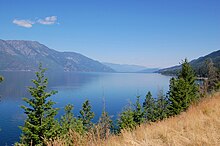
[26] Bedrock composes much of the streambed in the upper and lower reaches of the Kootenay, but in the middle portion, alluvial sediments allow the river to meander over a broader valley floor.
His expedition made it downstream to Columbia Lake but had some trouble making their way back to Alberta; the return route they had chosen proved too dangerous to negotiate.
After trading for some horses and new supplies from a band of Ktunaxa, they made it back over the Rockies later that year through North Kootenay Pass near Lower and Upper Kananaskis Lakes, after traveling up the Elk River.
Palliser's earlier travels were credited for being a "vital forerunner to the European settlement of the Prairies [of central Canada], providing volumes of information on the resources of this vast region.
Instead of crossing the Rockies, as Thompson did, Palliser set out from Fort Colville, a Hudson's Bay Company trading post near Kettle Falls on the Columbia River.
Palliser was told by Ktunaxa tribal members that a trail already existed along the Kootenay River, terminating at Columbia Lake, but was in decrepit condition (having been out of use for many years) and "entirely impracticable for horses".
By 1865 the peak of the rush was over, and the diggings had been found not as rich as previously believed when news arrived in 1865 of the strikes in the Big Bend of the Columbia and the bulk of the mining population moved there en masse.
[51][52] Fisherville, which had a Hudson's Bay post and other businesses, continued on with a few hundred residents for a few years (most of them Chinese by the end, as was the case with many other BC gold towns also) but was eclipsed as a supply centre with the creation of nearby Fort Steele.
[58] In the 20th century, members of a Russian religious sect called the Doukhobors living in the plains of Saskatchewan in central Canada were facing persecution, internal problems, and land confiscation by the Canadian government.
They also cleared areas of level ground in order to plant orchards and fields and constructed sawmills on the Columbia and Kootenay rivers to process the logs into lumber.
[76] Then in 1924, on a routine rail trip to Grand Forks, Peter Verigin and seven other people were killed by a dynamite explosion that completely destroyed the coach that he was traveling in.
[69] Despite the economic reforms he created in response to debt to the federal government, his arrival coincided with a terrible depression and bankruptcy which caused the Doukhobors to lose most of their lands.
[83][84] The other sections of the river flow through far more rugged terrain and are characterized by braiding, low nutrient content, shifting channels and coarse sediments, making it difficult for riparian zones to be established, as is with most of its upper and lower tributaries.
This biologically diverse area, the Kootenay Flats, once supported over 1 million migratory birds every year, before the river was diked and many of the wetlands converted to agriculture.
[96] Even before non-aboriginal people came to the region, the Kootenay River valley was an important path of trade and transport between the tribes of the Canadian Rockies and the Idaho Panhandle, mostly between the Ktunaxa (who practiced agriculture and aquaculture)[97] and the Salish, Blackfeet and Pend d'Oreilles of the south and east, and with the Shuswap in the north.
The physiographic continuation of the Kootenai Valley southwards from present-day Bonners Ferry, Idaho into the Pend Oreille basin via the Purcell Trench[16][17] formed a natural corridor through which natives of the area could interact.
[100] Lumber was required for the construction of buildings, forts, railroad tracks, and boats, and today is exported from the region in great amounts providing jobs and income for inhabitants of the area.
Commercial navigation began with steamboats in the 19th century to transport ores, lumber, passengers and other imported and exported products between the Kootenay River valley and the Canadian Pacific Railway station at Golden, British Columbia.
[104] The East Kootenay is the most important coal-producing area of British Columbia,[105] has since 1898 produced over 500 million tons,[105] and about 25 percent of the world's steel-making coal comes from the region.
[109] The seven dams on the Kootenay serve many purposes, ranging from generation of local electricity to regulation of Columbia River flow between Canada and the United States.
The canal travels several kilometers, parallel to and above the river to utilize the roughly 84-metre (276 ft) high water drop in elevation between Kootenay Lake and South Slocan, bypassing the old dams.
The uncontrolled discharge past the Canada-U.S. border created problems for electricity generation in the US, and Canada also wanted to utilize the Columbia river for the production of hydroelectric power.
However, operation of the dams has led to environmental problems in both rivers because they have caused unnatural flow fluctuations, blocked fish migration, flooded fertile agricultural land, and forced over 2,000 people to relocate.
[143] Kootenai Falls, which drops some 17 metres (56 ft) within a run of a few hundred meters, forms a natural boundary between fishes of the upper and lower river, but Libby Dam, several kilometres upstream, is an even more formidable barrier.