Kopet Dag
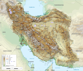
The Köpet Dag, Kopet Dagh, or Koppeh Dagh (Turkmen: Köpetdag; Persian: کپهداغ), also known as the Turkmen-Khorasan Mountain Range,[1] is a mountain range on the border between Turkmenistan and Iran that extends about 650 kilometres (400 mi) along the border southeast of the Caspian Sea, stretching northwest-southeast from near the Caspian Sea in the northwest to the Harirud River in the southeast.
In the second half of the last century, Russian scholars who studied in the Kopetdag passed the name onto maps as the name of the entire range and spread it to the public.
Many of the elders living in the foothills of the Kopetdag do not know the name Kopetdag...Vambery conjectures that the word kopet is derived from the words kubbet, kuppe (perhaps a lot — S.A.)...Pomerantsev also interprets the name as "multi-mountain" (mountain range), while the locals consider it part of the mythical Cape Mountain in Kopet, but these interpretations are incorrect.
This collision folded the entire rocks that had been deposited in this geosyncline or basin from the Jurassic to the Miocene and formed the Kopet Dag Mountains.
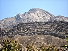
The Kopet Dag Range is a region characterized by foothills, dry and sandy slopes, mountain plateaus, and steep ravines.
This region is dotted with the multi-period hallmarks characteristic of the ancient Near East, similar to those southwest of the Kopet Dag in the Gorgan Plain in Iran.