Kosovo field
The plain stretches from Mitrovica southwards including Obiliq, Kosovo Polje (which lies in the centre), Lipjan, and almost to Kaçanik.
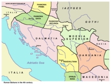
Praevalitana (the region before the valley), a province that bordered Dardania was named after the fact that it was located directly to the west of the field.
In the recorded version in Constantinople, the geographical location of Ulpiana, which was a settlement in the field of Kosovo, is described in Greek as Eucharis Koilas (the Gracious Valley).
Serbian ruler Stefan Lazarević (1389–1427) erected a marble column with inscriptions on the field, in memory of his father.
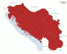
Kosovo and Vojvodina, another formerly autonomous region of Serbia,[clarification needed] had practically comparable status with the other six Yugoslav republics according to constitutional revisions made in 1971.
During the war, the Kosovo Liberation Army and FR Yugoslavia forces actively battled around the region, especially the parts in which many Albanians resided.