Kumbakonam
Kumbakonam (formerly spelt as Coombaconum or Combaconum),[1] or Kudanthai, is a city municipal corporation in the Thanjavur district in the Indian state of Tamil Nadu.
It rose to be a prominent town between the seventh and ninth centuries AD, when it served as a capital of the Medieval Cholas.
In 1866, Kumbakonam was officially constituted as a municipality, which today comprises 48 wards, making it the second largest local civil body in Thanjavur district.
The kumbha is believed to have been displaced by a pralaya (dissolution of the universe) and ultimately came to rest at the spot where the town of Kumbakonam now stands.
The present-day Kumbakonam is believed to be the site of the ancient town of Kudavayil where the Early Chola king Karikala held his court.
The town of Pazhaiyaarai, 8 km (5.0 mi) from Kumbakonam was the capital of the Chola Empire in the ninth century.
[16][17][18][19][20] When the Vijayanagar Empire fell in 1565, there was a mass influx of poets, musicians and cultural artists from the kingdom.
[4][22][23][24] When Tipu Sultan invaded the east coast of South India in 1784, Kumbakonam bore the brunt of his invasion.
[25] Kumbakonam was eventually ceded to the British East India Company in 1799 by the Thanjavur Maratha ruler Serfoji II (1777–1832)[15] and reached the zenith of its prosperity in the late 19th and early 20th century[26] when it emerged as an important center of Brahminism,[27] Hindu religion and European education in the Madras Presidency.
[28] Kumbakonam continued to grow even after India's independence though it fell behind the nearby town of Thanjavur in terms of population and administrative importance.
[36] It lies in the region called the "Old delta" which comprises the north-western taluks of Thanjavur district that have been naturally irrigated by the waters of the Cauvery and its tributaries for centuries in contrast to the "New Delta" comprising the southern taluks that were brought under irrigation by the construction of the Grand Anicut canal and the Vadavar canal in 1934.
[7] Although the Cauvery delta is usually hot, the climate of Kumbakonam and other surrounding towns is generally healthy[40] and moderate.
[48][49] This granular ridge projects further eastwards penetrating the Puducherry depression and forms a hard layer of cretaceous rock underneath the sedimentary topsoil.
[26] The town was upgraded to a Municipal Corporation on 24 August 2021, with an administration authority area of 42.9 km2 (16.6 sq mi).
[78] The functions of the municipality are devolved into six departments: General, Engineering, Revenue, Public Health, Town planning and the Computer Wing.
[81][82] Despite being a hub of militant Communism in the 1950s,[15] Kumbakonam voted for the Indian National Congress in the first five state elections held between 1952 and 1977.
[97] Suburban localities are under the jurisdiction of Swamimalai, Patteswarm, Nachiyarkovil, Tiruvidamarudhur, Thiruneelakudi police stations.
The important products of Kumbakonam include brass, bronze, copper and pewter vessels, silk and cotton cloths, sugar, indigo and pottery.
[99] The Tamil Nadu Handicraft Development Corporation had been established in the nearby town of Swamimalai in order to train bronze artisans.
[116] Roadside drains carry untreated sewage out of the town to let out raw into the sea or accumulate in a low-lying area.
[116] Kumbakonam comes under the Cauvery River Delta Area (CRDA) of the Bharat Sanchar Nigam Limited (BSNL), India's state-owned telecom and internet services provider.
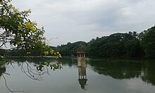
[120] The Nageswaraswamy Temple has a separate shrine for the Sun god Surya who is believed to have worshipped Shiva at this place.
The present structure of the temple having a twelve-storey high tower was constructed by Nayak kings in the 15th century.
[132] There is also a branch of the Vaishnava Ahobila mutt in Kumbakonam, who administers Thirupulamboothangudi and Aadanur ,having influence in Thirunaraiyur, Thirukudanthai, and Thiruvinnagar.
[136] There are regular government and private bus services to Chennai, Thanjavur, Mannargudi, Tiruchirapalli, Chidambaram, Thiruvarur, Mayiladuthurai, Nagapattinam, Coimbatore, Tiruppur, Palani, Thoothukudi, Rameswaram, Tiruchendur, Salem, Edapaddi, Vellore, Kumuli, Cumbum, Karaikudi, Pudukkottai, Neyveli, Madurai, Sivagangai, Thiruthuraipoondi, Pattukkottai, Muthupet, Puducherry, and Tirunelveli.
[138] On 1 July 1997, the organization was renamed Tamil Nadu State Transport Corporation, Kumbakonam and presently forms division no.
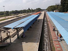
There are regular express trains that connect Kumbakonam with major cities in the state like Chennai, Coimbatore, Madurai and Tiruchirapalli.
[140] The upgrading of NH 36 from two-lane to four-line is under progress, which upon completion will greatly reduce to time of travel to Thanjavur and Chennai.
It is recorded that as late as the 1950s, landlords and rich farmers travelled mostly by bullock carts except for rare long journeys which they undertook by buses or motor vehicles.
[127][145][146][147][148] Kumbakonam emerged as an important centre of education in the late 19th century and was known as the "Cambridge of South India".