Kumtag Desert
The Kumtag Desert (Chinese: 库姆塔格沙漠; pinyin: Kùmǔtǎgé Shāmò, "kum-tag" meaning "sand-mountain" in a number of Turkic languages), is an arid landform in Northwestern China, which was proclaimed as a national park in the year 2002.
On the east side the Kumtag is an unbroken plain about 100 miles from north to south that runs from the Taklamakan to Gansu province and Mongolia.
The Kumtag Desert is expanding and threatening to engulf previously productive lands with its arid wasteland character.
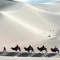
According to the AFP news report of November, 2007: "Towering sand dunes [of the Kumtag Desert] loom over the ancient Chinese city of Dunhuang".
[4] To mitigate the desertification, the town of Dunhuang has placed severe limitations on immigration, and has also placed restrictions on new water-well development or new farm additions.
Next comes, sharply demarcated from the zone just described, a more or less thin kamish steppe growing on level ground; and this in turn is followed by another very narrow belt of sand, immediately south of Achik-kuduk Finally in the extreme north we have the characteristic and sharply defined belt of kamish steppe, stretching from east-northeast to west-southwest and bounded on north and south by high, sharp cut clay terraces.
"[1][5] The moving sands of the Kumtag are of a concern for the designers of the Golmud–Dunhuang Railway, which will cross the eastern edge of this desert in the Shashangou area, between Dunhuang and the Altyn-Tagh-Qilian mountain system.