Kunar Province
N2KL was the designation used by the US and Coalition Forces in Afghanistan for the rugged region along the Afghanistan–Pakistan border opposite Pakistan's Federally Administered Tribal Areas (merged in 2018 with Khyber Pakhtunkhwa).
The Kunar is a primary draining conduit for the Hindu Kush basin and several tributaries, including the Pech, which form distinct and significant valleys in the area.
The mountains, narrow valleys with steep walls, and rivers present formidable natural obstacles and have historically constrained all movement through the province.
Even in the early 21st century, movement on foot, with pack animals, or with motorized vehicles is extremely limited and channeled due to the significant geographic restrictions.
Many famous historical figures are believed to have visited the area, including Alexander the Great, Mahmud Ghaznavi, Xuanzang, Ibn Battuta, and others.
[citation needed] Archaeologists have dated to AD 800–1000 a fortification system overlooking a Muslim cemetery at Chaga Serai (near the Pech-Kunar confluence).
He also describes agricultural products: citron, oranges, coriander, orchards, strong yellow wines, and a burial custom wherein a woman whose corpse moved was considered to have done good things in life.
The major city of Chitral (in modern Pakistan) was the base of a Mehtar (King), who ruled under the Maharajah of Kashmir[10] According to a US Army paper, the Pashtuns of Kunar and the Kafirs of Kunar/Nuristan eventually joined in the 20th century.
[12][13][14] Later, over ten-thousand Soviet and Afghan communist troops invaded the region, resulting in a massive refugee flow of the populace into Khyber Pakhtunkhwa, Pakistan.
[11] Eventually one of the Mujahideen leaders, Jamil al-Rahman, formed a movement that had a very strict interpretation of Islam, along the lines of Wahhabism and/or Salafism.
When the Soviets left in 1988, the leader of the Mujahideen group Hizb-i-Islami, Gulbuddin Hekmatyar, began to fight with Jamil al-Rahman over control of the area.
[11] After the September 11 attacks of 2001, Afghanistan was invaded by United States and other NATO countries provided direct support to the Northern Alliance forces fighting the Taliban regime, which was quickly toppled and fled to remote areas.
During the 19th century British military expeditions, the 1980s Soviet occupation, and the latest conflict, Kunar has been a favoured spot of insurgent groups.
Its impenetrable terrain, cave networks and the border with the semi-autonomous Pakistani Khyber Pakhtunkhwa provide significant advantages for unconventional warfare and militant groups.
Like many of the mountainous eastern provinces of Afghanistan, the groups involved in armed conflict vary greatly in strength and purpose.
Native Taliban forces mingle with foreign al-Qaeda fighters, while former mujahadeen militias, such as Hekmatyar's Hezb-e-Islami Gulbuddin, continue to operate as they did in the chaotic post-Soviet years.
Another strong militia in the region is the Hezbi Islami faction of the late Mulavi Younas Khalis, who had his headquarters in neighboring Nuristan Province.
On 16 April 2022, Pakistani airstrikes and rocket attacks targeted the Chogam village of Shultan District, killing three girls, two boys, and one woman, and wounding one man.
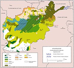
The major tribes of Kunar are the Safi, Tarkani, Mahmund, Salarzai, Ghoryakhel, Mashwani, Khogyani, Shinwari, Mohmand and Yousafzai.
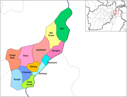
[31][32][33] The districts in Kunar Province as of March 2009 are:[34] Asadabad hosts both an American Provincial Reconstruction Team at nearby Forward Operating Base Wright and a UNAMA development office.
Documentary author James F. Christ has published numerous titles about the fighting in Kunar and Nuristan provinces, mainly from 2005 to 2007 with the 10th Mountain Division and Afghan National Army ETT advisors.